Akankpa geodata
Akankpa (Cross River) is a populated place; located in Nigeria in Africa/Lagos (GMT+1) time zone. With population of 7,000 people, there are 416 cities with bigger population in this country. Compared to other cities in Nigeria, 92.9% of cities are located further ↑North; 66.7% of cities are located further ←West and 80.4% of cities have higher elevation than Akankpa. Note1


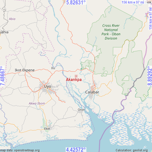
Akankpa GPS coordinates[2]
5° 7' 35.04" North, 8° 11' 23.28" East
| Map corner | latitude | longitude |
|---|---|---|
| Upper-left | 5.82631°, | 7.48667° |
| Center: | 5.1264°, | 8.1898° |
| Lower-right: | 4.42572°, | 8.89292° |
| Map W x H: | 155.7×155.7 km | = 96.7×96.7mi |
| max Lat: | 13.7543° ⇑92.9% North |
| Akankpa: | 5.1264° |
| min Lat: | ⇓7.1% South 4.31231° |
| min Long | Akankpa | max Long |
| 2.73333° | 8.1898° | 14.46552° |
| W 66.7%⇐ | ⇒33.3% E |
Elevation
Elevation of Akankpa is 80 m = 262 ft, and this is 216.5 m = 710 ft below average elevation for this country.
| Max E: |
1599 m = 5246 ft | 80.4% |
| Avg. | 296.5 m = 973 ft | |
| Akankpa | 80 m = 262 ft | |
Min E: |
2 m = 7 ft | 19.6% |
See also: Nigeria elevation on elevation.city.
Geographical zone
Akankpa is located in North Torrid zone (between Equator and Tropic of Cancer). Distance of Equator is 570 km =354.2 mi to South.| Distance of | km | miles | from Akankpa |
|---|---|---|---|
| North Pole | 9437.1 | 5863.9 | to North |
| Arctic Circle | 6831.2 | 4244.7 | to North |
| Tropic Cancer | 2035.9 | 1265 | to North |
| Equator | 570 | 354.2 | to South |


Nearby cities:
15 places around Akankpa: (largest is in red/bold)
• Akamkpa
27.6 km =17.1 mi,  41°
41°
• Calabar
24 km =14.9 mi,  140°
140°
• Esuk Oron
36.7 km =22.8 mi,  168°
168°
• Eyofin
41.9 km =26 mi, 173°
• Idu
21.9 km =13.6 mi,  240°
240°
• Ikot Nakanda
42.3 km =26.3 mi,  129°
129°
• Itu
24.3 km =15.1 mi,  290°
290°
• Nung Udoe
34.3 km =21.3 mi,  227°
227°
• Odot
36.9 km =22.9 mi,  207°
207°
• Odukpani
16.4 km =10.2 mi,  87°
87°
• Oko Ita
33.4 km =20.8 mi,  282°
282°
• Okopedi
31.6 km =19.6 mi,  192°
192°
• Oron
34.2 km =21.3 mi, 171°
• Urue Offong
41.6 km =25.8 mi,  183°
183°
• Uyo
29.6 km =18.4 mi,  253°
253°
Sources, notices
• [Note1] Compared only with cities in Nigeria existing in our database
• [Src1] Map data: © OpenStreetMap contributors (CC-BY-SA)
• [Src2] Other city data from geonames.org with taken over terms of usage.
• [Src3] Geographical zone / Annual Mean Temperature by Robert A. Rohde @ Wikipedia
