Calabar geodata
Calabar (Cross River) is a seat of a first-order administrative division; located in Nigeria in Africa/Lagos (GMT+1) time zone. With population of 461,796 people, there are 20 cities with bigger population in this country. Compared to other cities in Nigeria, 94.7% of cities are located further ↑North; 69.1% of cities are located further ←West and 89.1% of cities have higher elevation than Calabar. Note1


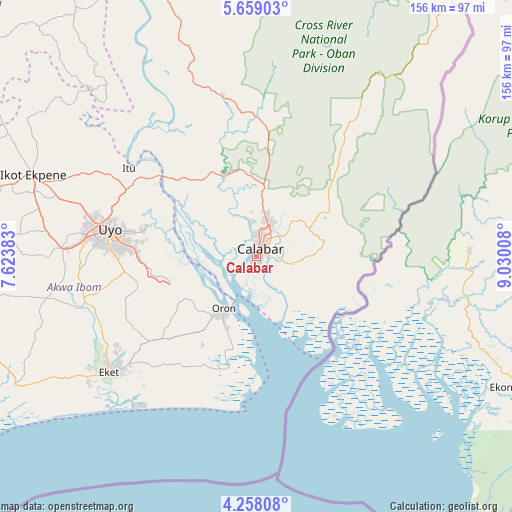
Calabar GPS coordinates[2]
4° 57' 32.148" North, 8° 19' 37.02" East
| Map corner | latitude | longitude |
|---|---|---|
| Upper-left | 5.65903°, | 7.62383° |
| Center: | 4.95893°, | 8.32695° |
| Lower-right: | 4.25808°, | 9.03008° |
| Map W x H: | 155.8×155.8 km | = 96.8×96.8mi |
| max Lat: | 13.7543° ⇑94.7% North |
| Calabar: | 4.95893° |
| min Lat: | ⇓5.3% South 4.31231° |
| min Long | Calabar | max Long |
| 2.73333° | 8.32695° | 14.46552° |
| W 69.1%⇐ | ⇒30.9% E |
Elevation
Elevation of Calabar is 37 m = 121 ft, and this is 259.5 m = 851 ft below average elevation for this country.
| Max E: |
1599 m = 5246 ft | 89.1% |
| Avg. | 296.5 m = 973 ft | |
| Calabar | 37 m = 121 ft | |
Min E: |
2 m = 7 ft | 10.9% |
See also: Calabar elevation on elevation.city.
Geographical zone
Calabar is located in North Torrid zone (between Equator and Tropic of Cancer). Distance of Equator is 551.4 km =342.6 mi to South.| Distance of | km | miles | from Calabar |
|---|---|---|---|
| North Pole | 9455.7 | 5875.5 | to North |
| Arctic Circle | 6849.8 | 4256.3 | to North |
| Tropic Cancer | 2054.5 | 1276.6 | to North |
| Equator | 551.4 | 342.6 | to South |


Nearby cities:
15 places around Calabar: (largest is in red/bold)
• Akamkpa
39.4 km =24.5 mi,  4°
4°
• Akankpa
24 km =14.9 mi,  320°
320°
• Enwang
34.6 km =21.5 mi,  193°
193°
• Esuk Oron
19.2 km =11.9 mi,  205°
205°
• Eyofin
25.4 km =15.8 mi,  204°
204°
• Idu
35.2 km =21.9 mi,  282°
282°
• Ikang
29.5 km =18.3 mi,  129°
129°
• Ikot Nakanda
19.3 km =12 mi,  115°
115°
• Nung Udoe
40.6 km =25.2 mi,  263°
263°
• Odot
35 km =21.7 mi,  246°
246°
• Odukpani
19.5 km =12.1 mi, 3°
• Okopedi
25.4 km =15.8 mi,  241°
241°
• Oron
18.3 km =11.4 mi, 213°
• Uquo
44.7 km =27.8 mi,  221°
221°
• Urue Offong
28.9 km =18 mi, 217°
Sources, notices
• [Note1] Compared only with cities in Nigeria existing in our database
• [Src1] Map data: © OpenStreetMap contributors (CC-BY-SA)
• [Src2] Other city data from geonames.org with taken over terms of usage.
• [Src3] Geographical zone / Annual Mean Temperature by Robert A. Rohde @ Wikipedia
