Uyo geodata
Uyo (Akwa Ibom) is a seat of a first-order administrative division; located in Nigeria in Africa/Lagos (GMT+1) time zone. With population of 436,606 people, there are 21 cities with bigger population in this country. Compared to other cities in Nigeria, 93.9% of cities are located further ↑North; 62.2% of cities are located further ←West and 87.8% of cities have higher elevation than Uyo. Note1


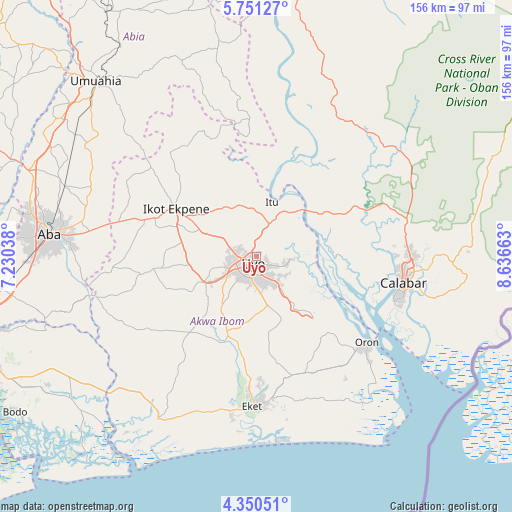
Uyo GPS coordinates[2]
5° 3' 4.572" North, 7° 56' 0.6" East
| Map corner | latitude | longitude |
|---|---|---|
| Upper-left | 5.75127°, | 7.23038° |
| Center: | 5.05127°, | 7.9335° |
| Lower-right: | 4.35051°, | 8.63663° |
| Map W x H: | 155.7×155.8 km | = 96.7×96.8mi |
| max Lat: | 13.7543° ⇑93.9% North |
| Uyo: | 5.05127° |
| min Lat: | ⇓6.1% South 4.31231° |
| min Long | Uyo | max Long |
| 2.73333° | 7.9335° | 14.46552° |
| W 62.2%⇐ | ⇒37.8% E |
Elevation
Elevation of Uyo is 45 m = 148 ft, and this is 251.5 m = 825 ft below average elevation for this country.
| Max E: |
1599 m = 5246 ft | 87.8% |
| Avg. | 296.5 m = 973 ft | |
| Uyo | 45 m = 148 ft | |
Min E: |
2 m = 7 ft | 12.2% |
See also: Uyo elevation on elevation.city.
Geographical zone
Uyo is located in North Torrid zone (between Equator and Tropic of Cancer). Distance of Equator is 561.6 km =349 mi to South.| Distance of | km | miles | from Uyo |
|---|---|---|---|
| North Pole | 9445.4 | 5869.1 | to North |
| Arctic Circle | 6839.5 | 4249.9 | to North |
| Tropic Cancer | 2044.3 | 1270.3 | to North |
| Equator | 561.6 | 349 | to South |


Nearby cities:
15 places around Uyo: (largest is in red/bold)
• Abak
17.7 km =11 mi,  244°
244°
• Afaha Ikot Ebak
31.7 km =19.7 mi,  285°
285°
• Afaha Offiong
21.2 km =13.2 mi,  188°
188°
• Akankpa
29.6 km =18.4 mi,  73°
73°
• Arochukwu
37.7 km =23.4 mi,  356°
356°
• Etinan
24.9 km =15.5 mi,  201°
201°
• Idu
9.6 km =6 mi,  104°
104°
• Ikot Edibon
31.3 km =19.4 mi,  180°
180°
• Ikot Ekpene
28.2 km =17.5 mi,  300°
300°
• Itu
17.6 km =10.9 mi,  18°
18°
• Nung Udoe
15.3 km =9.5 mi,  167°
167°
• Odot
27.1 km =16.8 mi,  154°
154°
• Oko Ita
16.2 km =10.1 mi,  344°
344°
• Okopedi
31 km =19.3 mi,  136°
136°
• Utu Etim Ekpo
36.2 km =22.5 mi,  261°
261°
Sources, notices
• [Note1] Compared only with cities in Nigeria existing in our database
• [Src1] Map data: © OpenStreetMap contributors (CC-BY-SA)
• [Src2] Other city data from geonames.org with taken over terms of usage.
• [Src3] Geographical zone / Annual Mean Temperature by Robert A. Rohde @ Wikipedia
