Enwang geodata
Enwang (Akwa Ibom) is a seat of a second-order administrative division; located in Nigeria in Africa/Lagos (GMT+1) time zone. In our database, there are 451 cities with bigger population. Compared to other cities in Nigeria, 98.8% of cities are located further ↑North; 67.8% of cities are located further ←West and 90.3% of cities have higher elevation than Enwang. Note1


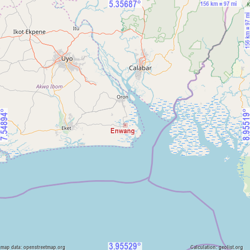
Enwang GPS coordinates[2]
4° 39' 23.148" North, 8° 15' 7.416" East
| Map corner | latitude | longitude |
|---|---|---|
| Upper-left | 5.35687°, | 7.54894° |
| Center: | 4.65643°, | 8.25206° |
| Lower-right: | 3.95529°, | 8.95519° |
| Map W x H: | 155.8×155.8 km | = 96.8×96.8mi |
| max Lat: | 13.7543° ⇑98.8% North |
| Enwang: | 4.65643° |
| min Lat: | ⇓1.2% South 4.31231° |
| min Long | Enwang | max Long |
| 2.73333° | 8.25206° | 14.46552° |
| W 67.8%⇐ | ⇒32.2% E |
Elevation
Elevation of Enwang is 28 m = 92 ft, and this is 268.5 m = 881 ft below average elevation for this country.
| Max E: |
1599 m = 5246 ft | 90.3% |
| Avg. | 296.5 m = 973 ft | |
| Enwang | 28 m = 92 ft | |
Min E: |
2 m = 7 ft | 9.7% |
See also: Nigeria elevation on elevation.city.
Geographical zone
Enwang is located in North Torrid zone (between Equator and Tropic of Cancer). Distance of Equator is 517.7 km =321.7 mi to South.| Distance of | km | miles | from Enwang |
|---|---|---|---|
| North Pole | 9489.3 | 5896.4 | to North |
| Arctic Circle | 6883.4 | 4277.1 | to North |
| Tropic Cancer | 2088.2 | 1297.5 | to North |
| Equator | 517.7 | 321.7 | to South |


Nearby cities:
15 places around Enwang: (largest is in red/bold)
• Abat
43 km =26.7 mi,  264°
264°
• Calabar
34.6 km =21.5 mi,  13°
13°
• Eket
36.3 km =22.6 mi,  267°
267°
• Esuk Oron
16.3 km =10.1 mi,  0°
0°
• Eyofin
10.8 km =6.7 mi,  347°
347°
• Ikang
34.3 km =21.3 mi,  64°
64°
• Ikot Edibon
37.8 km =23.5 mi,  289°
289°
• Ikot Nakanda
36.1 km =22.4 mi,  45°
45°
• Nung Udoe
43.1 km =26.8 mi,  312°
312°
• Odot
30.6 km =19 mi, 309°
• Okopedi
25.6 km =15.9 mi,  326°
326°
• Oron
18.5 km =11.5 mi, 354°
• Upenekang
31.7 km =19.7 mi,  252°
252°
• Uquo
21.4 km =13.3 mi, 270°
• Urue Offong
14.2 km =8.8 mi,  318°
318°
Sources, notices
• [Note1] Compared only with cities in Nigeria existing in our database
• [Src1] Map data: © OpenStreetMap contributors (CC-BY-SA)
• [Src2] Other city data from geonames.org with taken over terms of usage.
• [Src3] Geographical zone / Annual Mean Temperature by Robert A. Rohde @ Wikipedia
