Iyara geodata
Iyara (Kogi) is a seat of a second-order administrative division; located in Nigeria in Africa/Lagos (GMT+1) time zone. In our database, there are 451 cities with bigger population. Compared to other cities in Nigeria, 55.4% of cities are located further ↑North; 70.8% of cities are located further →East and 79.1% of cities have lower elevation than Iyara. Note1


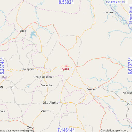
Iyara GPS coordinates[2]
7° 50' 35.7" North, 5° 58' 14.196" East
| Map corner | latitude | longitude |
|---|---|---|
| Upper-left | 8.5392°, | 5.26748° |
| Center: | 7.84325°, | 5.97061° |
| Lower-right: | 7.14614°, | 6.67373° |
| Map W x H: | 154.9×154.9 km | = 96.3×96.3mi |
| max Lat: | 13.7543° ⇑55.4% North |
| Iyara: | 7.84325° |
| min Lat: | ⇓44.6% South 4.31231° |
| min Long | Iyara | max Long |
| 2.73333° | 5.97061° | 14.46552° |
| W 29.2%⇐ | ⇒70.8% E |
Elevation
Elevation of Iyara is 463 m = 1519 ft, and this is 166.5 m = 546 ft above average elevation for this country.
| Max E: |
1599 m = 5246 ft | 20.9% |
| Iyara | 463 m 1519 ft | |
| Avg. | 296.5 m = 973 ft | |
Min E: |
2 m = 7 ft | 79.1% |
See also: Nigeria elevation on elevation.city.
Geographical zone
Iyara is located in North Torrid zone (between Equator and Tropic of Cancer). Distance of Equator is 872.1 km =541.9 mi to South.| Distance of | km | miles | from Iyara |
|---|---|---|---|
| North Pole | 9135 | 5676.2 | to North |
| Arctic Circle | 6529.1 | 4057 | to North |
| Tropic Cancer | 1733.8 | 1077.3 | to North |
| Equator | 872.1 | 541.9 | to South |


Nearby cities:
15 places around Iyara: (largest is in red/bold)
• Akpafa
45.8 km =28.5 mi,  154°
154°
• Ikare
42.6 km =26.5 mi,  214°
214°
• Ikole-Ekiti
51.2 km =31.8 mi,  263°
263°
• Isanlu-Itedoijowa
50.2 km =31.2 mi,  342°
342°
• Isua
43.8 km =27.2 mi,  188°
188°
• Kabba
11.6 km =7.2 mi,  98°
98°
• Mopa
30.2 km =18.8 mi, 343°
• Obangede
35.3 km =21.9 mi,  134°
134°
• Ode
29.1 km =18.1 mi, 258°
• Ode-Ekiti
51.2 km =31.8 mi,  244°
244°
• Ogaminana
38.9 km =24.2 mi,  135°
135°
• Oka
46.5 km =28.9 mi,  203°
203°
• Oke-Agbe
32.2 km =20 mi,  226°
226°
• Okene
43.7 km =27.2 mi, 138°
• Omuo-Ekiti
28.9 km =18 mi,  250°
250°
Sources, notices
• [Note1] Compared only with cities in Nigeria existing in our database
• [Src1] Map data: © OpenStreetMap contributors (CC-BY-SA)
• [Src2] Other city data from geonames.org with taken over terms of usage.
• [Src3] Geographical zone / Annual Mean Temperature by Robert A. Rohde @ Wikipedia
