Isua geodata
Isua (Ondo) is a seat of a second-order administrative division; located in Nigeria in Africa/Lagos (GMT+1) time zone. In our database, there are 451 cities with bigger population. Compared to other cities in Nigeria, 62.8% of cities are located further ↑North; 71.4% of cities are located further →East and 62.4% of cities have lower elevation than Isua. Note1


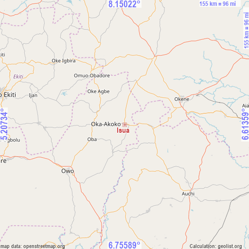
Isua GPS coordinates[2]
7° 27' 12.996" North, 5° 54' 37.692" East
| Map corner | latitude | longitude |
|---|---|---|
| Upper-left | 8.15022°, | 5.20734° |
| Center: | 7.45361°, | 5.91047° |
| Lower-right: | 6.75589°, | 6.61359° |
| Map W x H: | 155×155 km | = 96.3×96.3mi |
| max Lat: | 13.7543° ⇑62.8% North |
| Isua: | 7.45361° |
| min Lat: | ⇓37.2% South 4.31231° |
| min Long | Isua | max Long |
| 2.73333° | 5.91047° | 14.46552° |
| W 28.6%⇐ | ⇒71.4% E |
Elevation
Elevation of Isua is 357 m = 1171 ft, and this is 60.5 m = 198 ft above average elevation for this country.
| Max E: |
1599 m = 5246 ft | 37.6% |
| Isua | 357 m 1171 ft | |
| Avg. | 296.5 m = 973 ft | |
Min E: |
2 m = 7 ft | 62.4% |
See also: Nigeria elevation on elevation.city.
Geographical zone
Isua is located in North Torrid zone (between Equator and Tropic of Cancer). Distance of Equator is 828.8 km =515 mi to South.| Distance of | km | miles | from Isua |
|---|---|---|---|
| North Pole | 9178.3 | 5703.1 | to North |
| Arctic Circle | 6572.4 | 4083.9 | to North |
| Tropic Cancer | 1777.2 | 1104.3 | to North |
| Equator | 828.8 | 515 | to South |


Nearby cities:
15 places around Isua: (largest is in red/bold)
• Akpafa
26.5 km =16.5 mi,  85°
85°
• Emure-Ekiti
49.8 km =30.9 mi,  267°
267°
• Igarra
27.8 km =17.3 mi,  129°
129°
• Ikare
19.1 km =11.9 mi,  294°
294°
• Iyara
43.8 km =27.2 mi,  8°
8°
• Kabba
45.3 km =28.1 mi,  23°
23°
• Obangede
36.9 km =22.9 mi,  59°
59°
• Ode
43.3 km =26.9 mi,  329°
329°
• Ode-Ekiti
45.3 km =28.1 mi,  298°
298°
• Ogaminana
37.3 km =23.2 mi,  65°
65°
• Oka
12 km =7.5 mi, 273°
• Oke-Agbe
26.9 km =16.7 mi,  321°
321°
• Okene
37.5 km =23.3 mi, 73°
• Omuo-Ekiti
39.7 km =24.7 mi, 328°
• Owo
45.8 km =28.5 mi,  231°
231°
Sources, notices
• [Note1] Compared only with cities in Nigeria existing in our database
• [Src1] Map data: © OpenStreetMap contributors (CC-BY-SA)
• [Src2] Other city data from geonames.org with taken over terms of usage.
• [Src3] Geographical zone / Annual Mean Temperature by Robert A. Rohde @ Wikipedia
