Isanlu-Itedoijowa geodata
Isanlu-Itedoijowa (Kogi) is a populated place; located in Nigeria in Africa/Lagos (GMT+1) time zone. With population of 15,087 people, there are 242 cities with bigger population in this country. Compared to other cities in Nigeria, 50.4% of cities are located further ↑North; 72% of cities are located further →East and 56.7% of cities have lower elevation than Isanlu-Itedoijowa. Note1


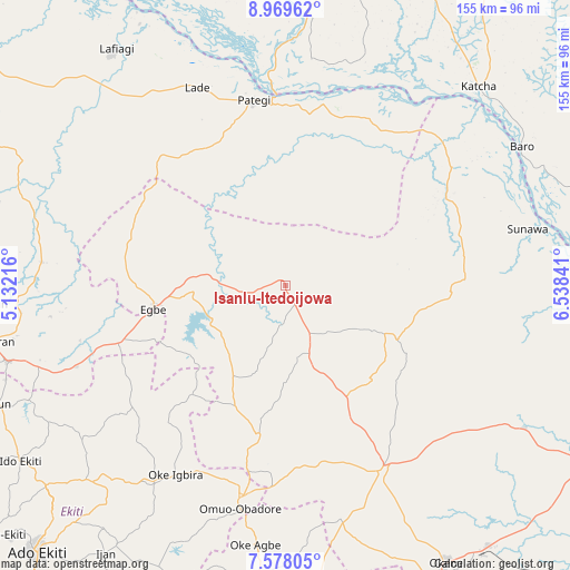
Isanlu-Itedoijowa GPS coordinates[2]
8° 16' 28.02" North, 5° 50' 7.008" East
| Map corner | latitude | longitude |
|---|---|---|
| Upper-left | 8.96962°, | 5.13216° |
| Center: | 8.27445°, | 5.83528° |
| Lower-right: | 7.57805°, | 6.53841° |
| Map W x H: | 154.7×154.7 km | = 96.1×96.1mi |
| max Lat: | 13.7543° ⇑50.4% North |
| Isanlu-Itedoijowa: | 8.27445° |
| min Lat: | ⇓49.6% South 4.31231° |
| min Long | Isanlu-Itedoijo | max Long |
| 2.73333° | 5.83528° | 14.46552° |
| W 28%⇐ | ⇒72% E |
Elevation
Elevation of Isanlu-Itedoijowa is 323 m = 1060 ft, and this is 26.5 m = 87 ft above average elevation for this country.
| Max E: |
1599 m = 5246 ft | 43.3% |
| Isanlu-Itedoijowa | 323 m 1060 ft | |
| Avg. | 296.5 m = 973 ft | |
Min E: |
2 m = 7 ft | 56.7% |
See also: Nigeria elevation on elevation.city.
Geographical zone
Isanlu-Itedoijowa is located in North Torrid zone (between Equator and Tropic of Cancer). Distance of Equator is 920 km =571.7 mi to South.| Distance of | km | miles | from Isanlu-Itedoijowa |
|---|---|---|---|
| North Pole | 9087 | 5646.4 | to North |
| Arctic Circle | 6481.1 | 4027.2 | to North |
| Tropic Cancer | 1685.9 | 1047.6 | to North |
| Equator | 920 | 571.7 | to South |


Nearby cities:
15 places around Isanlu-Itedoijowa: (largest is in red/bold)
• Araromi-Opin
68.1 km =42.3 mi,  250°
250°
• Baro
74.5 km =46.3 mi,  59°
59°
• Egbe
35.6 km =22.1 mi,  259°
259°
• Ikole-Ekiti
64.6 km =40.1 mi,  213°
213°
• Isanlu
2.4 km =1.5 mi,  309°
309°
• Iyara
50.2 km =31.2 mi,  162°
162°
• Iye-Ekiti
75.2 km =46.7 mi,  241°
241°
• Kabba
56.3 km =35 mi,  152°
152°
• Katcha
75.3 km =46.8 mi,  44°
44°
• Mopa
20 km =12.4 mi, 161°
• Ode
55.6 km =34.5 mi,  194°
194°
• Odo-Ere
31.5 km =19.6 mi,  265°
265°
• Oke-Agbe
70.7 km =43.9 mi, 186°
• Omuo-Ekiti
58.7 km =36.5 mi, 192°
• Patigi
51.2 km =31.8 mi,  350°
350°
Sources, notices
• [Note1] Compared only with cities in Nigeria existing in our database
• [Src1] Map data: © OpenStreetMap contributors (CC-BY-SA)
• [Src2] Other city data from geonames.org with taken over terms of usage.
• [Src3] Geographical zone / Annual Mean Temperature by Robert A. Rohde @ Wikipedia
