Ifo geodata
Ifo (Ogun) is a seat of a second-order administrative division; located in Nigeria in Africa/Lagos (GMT+1) time zone. With population of 88,272 people, there are 97 cities with bigger population in this country. Compared to other cities in Nigeria, 70.9% of cities are located further ↑North; 98.9% of cities are located further →East and 83.5% of cities have higher elevation than Ifo. Note1


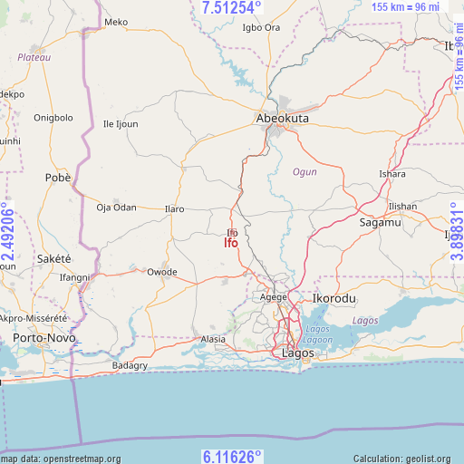
Ifo GPS coordinates[2]
6° 48' 53.676" North, 3° 11' 42.648" East
| Map corner | latitude | longitude |
|---|---|---|
| Upper-left | 7.51254°, | 2.49206° |
| Center: | 6.81491°, | 3.19518° |
| Lower-right: | 6.11626°, | 3.89831° |
| Map W x H: | 155.3×155.3 km | = 96.5×96.5mi |
| max Lat: | 13.7543° ⇑70.9% North |
| Ifo: | 6.81491° |
| min Lat: | ⇓29.1% South 4.31231° |
| min Long | Ifo | max Long |
| 2.73333° | 3.19518° | 14.46552° |
| W 1.1%⇐ | ⇒98.9% E |
Elevation
Elevation of Ifo is 65 m = 213 ft, and this is 231.5 m = 760 ft below average elevation for this country.
| Max E: |
1599 m = 5246 ft | 83.5% |
| Avg. | 296.5 m = 973 ft | |
| Ifo | 65 m = 213 ft | |
Min E: |
2 m = 7 ft | 16.5% |
See also: Ifo elevation on elevation.city.
Geographical zone
Ifo is located in North Torrid zone (between Equator and Tropic of Cancer). Distance of Equator is 757.7 km =470.8 mi to South.| Distance of | km | miles | from Ifo |
|---|---|---|---|
| North Pole | 9249.3 | 5747.2 | to North |
| Arctic Circle | 6643.4 | 4128 | to North |
| Tropic Cancer | 1848.2 | 1148.4 | to North |
| Equator | 757.7 | 470.8 | to South |


Nearby cities:
15 places around Ifo: (largest is in red/bold)
• Ado Odo
37.5 km =23.3 mi,  230°
230°
• Agege
26.9 km =16.7 mi,  145°
145°
• Festac Town
39.6 km =24.6 mi,  165°
165°
• Ifako
23.8 km =14.8 mi,  142°
142°
• Ikeja
29.2 km =18.1 mi, 146°
• Ikotun
31 km =19.3 mi, 165°
• Ilaro
21.6 km =13.4 mi,  292°
292°
• Itori
13.3 km =8.3 mi,  12°
12°
• Mushin
36.4 km =22.6 mi, 151°
• Ojota
33.8 km =21 mi, 141°
• Oshodi
33.2 km =20.6 mi, 150°
• Ota
14.6 km =9.1 mi,  163°
163°
• Owode
37.3 km =23.2 mi,  66°
66°
• Somolu
36.5 km =22.7 mi, 147°
• Surulere
39.2 km =24.4 mi, 152°
Sources, notices
• [Note1] Compared only with cities in Nigeria existing in our database
• [Src1] Map data: © OpenStreetMap contributors (CC-BY-SA)
• [Src2] Other city data from geonames.org with taken over terms of usage.
• [Src3] Geographical zone / Annual Mean Temperature by Robert A. Rohde @ Wikipedia
