Owode geodata
Owode (Ogun) is a seat of a second-order administrative division; located in Nigeria in Africa/Lagos (GMT+1) time zone. With population of 8,513 people, there are 370 cities with bigger population in this country. Compared to other cities in Nigeria, 69% of cities are located further ↑North; 95.2% of cities are located further →East and 72.7% of cities have higher elevation than Owode. Note1


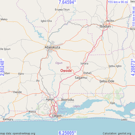
Owode GPS coordinates[2]
6° 56' 54.636" North, 3° 30' 20.196" East
| Map corner | latitude | longitude |
|---|---|---|
| Upper-left | 7.64594°, | 2.80248° |
| Center: | 6.94851°, | 3.50561° |
| Lower-right: | 6.25005°, | 4.20873° |
| Map W x H: | 155.2×155.2 km | = 96.4×96.4mi |
| max Lat: | 13.7543° ⇑69% North |
| Owode: | 6.94851° |
| min Lat: | ⇓31% South 4.31231° |
| min Long | Owode | max Long |
| 2.73333° | 3.50561° | 14.46552° |
| W 4.8%⇐ | ⇒95.2% E |
Elevation
Elevation of Owode is 134 m = 440 ft, and this is 162.5 m = 533 ft below average elevation for this country.
| Max E: |
1599 m = 5246 ft | 72.7% |
| Avg. | 296.5 m = 973 ft | |
| Owode | 134 m = 440 ft | |
Min E: |
2 m = 7 ft | 27.3% |
See also: Nigeria elevation on elevation.city.
Geographical zone
Owode is located in North Torrid zone (between Equator and Tropic of Cancer). Distance of Equator is 772.6 km =480.1 mi to South.| Distance of | km | miles | from Owode |
|---|---|---|---|
| North Pole | 9234.5 | 5738.1 | to North |
| Arctic Circle | 6628.6 | 4118.8 | to North |
| Tropic Cancer | 1833.3 | 1139.2 | to North |
| Equator | 772.6 | 480.1 | to South |


Nearby cities:
15 places around Owode: (largest is in red/bold)
• Abeokuta
29.1 km =18.1 mi,  322°
322°
• Agege
41.6 km =25.8 mi,  207°
207°
• Ebute Ikorodu
38.7 km =24 mi,  182°
182°
• Ifako
39.3 km =24.4 mi, 210°
• Ifo
37.3 km =23.2 mi,  246°
246°
• Ikeja
43.1 km =26.8 mi,  204°
204°
• Ikenne
24.9 km =15.5 mi,  111°
111°
• Ikorodu
37.1 km =23.1 mi, 179°
• Iperu
18.2 km =11.3 mi,  103°
103°
• Isara
20 km =12.4 mi,  75°
75°
• Itori
31.4 km =19.5 mi,  266°
266°
• Odeda
31.7 km =19.7 mi,  4°
4°
• Odogbolu
30.8 km =19.1 mi, 112°
• Ota
41.8 km =26 mi,  226°
226°
• Shagamu
19.1 km =11.9 mi,  125°
125°
Sources, notices
• [Note1] Compared only with cities in Nigeria existing in our database
• [Src1] Map data: © OpenStreetMap contributors (CC-BY-SA)
• [Src2] Other city data from geonames.org with taken over terms of usage.
• [Src3] Geographical zone / Annual Mean Temperature by Robert A. Rohde @ Wikipedia
