Itori geodata
Itori (Ogun) is a seat of a second-order administrative division; located in Nigeria in Africa/Lagos (GMT+1) time zone. In our database, there are 451 cities with bigger population. Compared to other cities in Nigeria, 69.1% of cities are located further ↑North; 98.8% of cities are located further →East and 91% of cities have higher elevation than Itori. Note1


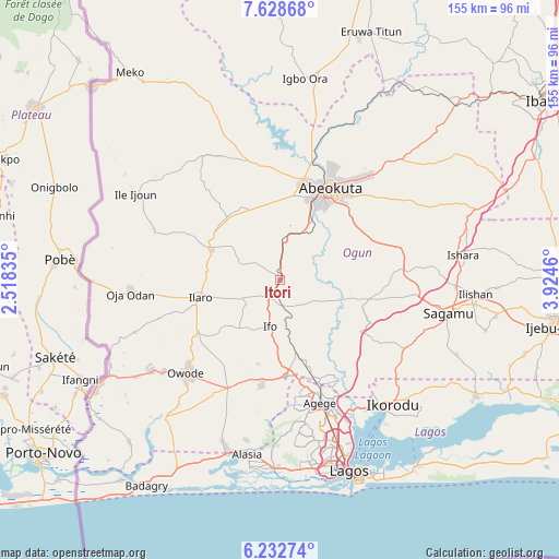
Itori GPS coordinates[2]
6° 55' 52.428" North, 3° 13' 17.292" East
| Map corner | latitude | longitude |
|---|---|---|
| Upper-left | 7.62868°, | 2.51835° |
| Center: | 6.93123°, | 3.22147° |
| Lower-right: | 6.23274°, | 3.9246° |
| Map W x H: | 155.2×155.2 km | = 96.4×96.4mi |
| max Lat: | 13.7543° ⇑69.1% North |
| Itori: | 6.93123° |
| min Lat: | ⇓30.9% South 4.31231° |
| min Long | Itori | max Long |
| 2.73333° | 3.22147° | 14.46552° |
| W 1.2%⇐ | ⇒98.8% E |
Elevation
Elevation of Itori is 24 m = 79 ft, and this is 272.5 m = 894 ft below average elevation for this country.
| Max E: |
1599 m = 5246 ft | 91% |
| Avg. | 296.5 m = 973 ft | |
| Itori | 24 m = 79 ft | |
Min E: |
2 m = 7 ft | 9% |
See also: Nigeria elevation on elevation.city.
Geographical zone
Itori is located in North Torrid zone (between Equator and Tropic of Cancer). Distance of Equator is 770.7 km =478.9 mi to South.| Distance of | km | miles | from Itori |
|---|---|---|---|
| North Pole | 9236.4 | 5739.2 | to North |
| Arctic Circle | 6630.5 | 4120 | to North |
| Tropic Cancer | 1835.2 | 1140.3 | to North |
| Equator | 770.7 | 478.9 | to South |


Nearby cities:
15 places around Itori: (largest is in red/bold)
• Abeokuta
28.4 km =17.6 mi,  28°
28°
• Agege
37.2 km =23.1 mi,  160°
160°
• Ayetoro
40.8 km =25.4 mi,  328°
328°
• Ebute Ikorodu
47.1 km =29.3 mi,  141°
141°
• Ifako
33.9 km =21.1 mi, 160°
• Ifo
13.3 km =8.3 mi,  192°
192°
• Ikeja
39.5 km =24.5 mi, 160°
• Ikorodu
47.2 km =29.3 mi, 138°
• Ikotun
43.3 km =26.9 mi,  173°
173°
• Ilaro
23.4 km =14.5 mi,  258°
258°
• Ojota
43.3 km =26.9 mi, 155°
• Oshodi
43.9 km =27.3 mi, 162°
• Ota
27 km =16.8 mi,  177°
177°
• Owode
31.4 km =19.5 mi,  86°
86°
• Somolu
46.8 km =29.1 mi, 158°
Sources, notices
• [Note1] Compared only with cities in Nigeria existing in our database
• [Src1] Map data: © OpenStreetMap contributors (CC-BY-SA)
• [Src2] Other city data from geonames.org with taken over terms of usage.
• [Src3] Geographical zone / Annual Mean Temperature by Robert A. Rohde @ Wikipedia
