Ado-Ekiti geodata
Ado-Ekiti (Ekiti) is a seat of a first-order administrative division; located in Nigeria in Africa/Lagos (GMT+1) time zone. With population of 424,340 people, there are 23 cities with bigger population in this country. Compared to other cities in Nigeria, 58.9% of cities are located further ↑North; 78.6% of cities are located further →East and 76.1% of cities have lower elevation than Ado-Ekiti. Note1


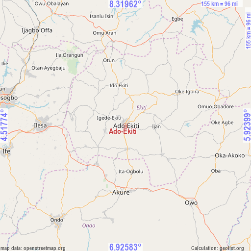
Ado-Ekiti GPS coordinates[2]
7° 37' 23.844" North, 5° 13' 15.132" East
| Map corner | latitude | longitude |
|---|---|---|
| Upper-left | 8.31962°, | 4.51774° |
| Center: | 7.62329°, | 5.22087° |
| Lower-right: | 6.92583°, | 5.92399° |
| Map W x H: | 155×155 km | = 96.3×96.3mi |
| max Lat: | 13.7543° ⇑58.9% North |
| Ado-Ekiti: | 7.62329° |
| min Lat: | ⇓41.1% South 4.31231° |
| min Long | Ado-Ekiti | max Long |
| 2.73333° | 5.22087° | 14.46552° |
| W 21.4%⇐ | ⇒78.6% E |
Elevation
Elevation of Ado-Ekiti is 439 m = 1440 ft, and this is 142.5 m = 468 ft above average elevation for this country.
| Max E: |
1599 m = 5246 ft | 23.9% |
| Ado-Ekiti | 439 m 1440 ft | |
| Avg. | 296.5 m = 973 ft | |
Min E: |
2 m = 7 ft | 76.1% |
See also: Ado-Ekiti elevation on elevation.city.
Geographical zone
Ado-Ekiti is located in North Torrid zone (between Equator and Tropic of Cancer). Distance of Equator is 847.6 km =526.7 mi to South.| Distance of | km | miles | from Ado-Ekiti |
|---|---|---|---|
| North Pole | 9159.4 | 5691.4 | to North |
| Arctic Circle | 6553.5 | 4072.2 | to North |
| Tropic Cancer | 1758.3 | 1092.6 | to North |
| Equator | 847.6 | 526.7 | to South |


Nearby cities:
15 places around Ado-Ekiti: (largest is in red/bold)
• Aramoko-Ekiti
21.8 km =13.5 mi,  294°
294°
• Ido-Ekiti
25.1 km =15.6 mi,  350°
350°
• Ifaki
18.7 km =11.6 mi,  9°
9°
• Igbara-Odo
22 km =13.7 mi,  232°
232°
• Igbara-Oke
29.6 km =18.4 mi,  217°
217°
• Igede-Ekiti
11.6 km =7.2 mi,  295°
295°
• Ijero-Ekiti
27.2 km =16.9 mi,  321°
321°
• Iju
25.8 km =16 mi,  170°
170°
• Ikere-Ekiti
14 km =8.7 mi,  175°
175°
• Ilare
32.5 km =20.2 mi,  201°
201°
• Ilawe-Ekiti
13.1 km =8.1 mi,  257°
257°
• Ipoti
32.1 km =19.9 mi,  330°
330°
• Ise-Ekiti
28.4 km =17.6 mi,  128°
128°
• Ita-Ogbolu
28.5 km =17.7 mi, 174°
• Oye-Ekiti
23.2 km =14.4 mi,  32°
32°
Sources, notices
• [Note1] Compared only with cities in Nigeria existing in our database
• [Src1] Map data: © OpenStreetMap contributors (CC-BY-SA)
• [Src2] Other city data from geonames.org with taken over terms of usage.
• [Src3] Geographical zone / Annual Mean Temperature by Robert A. Rohde @ Wikipedia
