Ilare geodata
Ilare (Ondo) is a populated place; located in Nigeria in Africa/Lagos (GMT+1) time zone. With population of 7,685 people, there are 393 cities with bigger population in this country. Compared to other cities in Nigeria, 64.5% of cities are located further ↑North; 80% of cities are located further →East and 60.3% of cities have lower elevation than Ilare. Note1


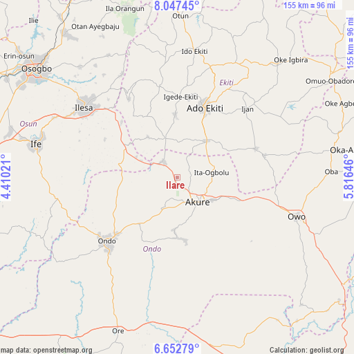
Ilare GPS coordinates[2]
7° 21' 2.412" North, 5° 6' 47.988" East
| Map corner | latitude | longitude |
|---|---|---|
| Upper-left | 8.04745°, | 4.41021° |
| Center: | 7.35067°, | 5.11333° |
| Lower-right: | 6.65279°, | 5.81646° |
| Map W x H: | 155.1×155.1 km | = 96.4×96.4mi |
| max Lat: | 13.7543° ⇑64.5% North |
| Ilare: | 7.35067° |
| min Lat: | ⇓35.5% South 4.31231° |
| min Long | Ilare | max Long |
| 2.73333° | 5.11333° | 14.46552° |
| W 20%⇐ | ⇒80% E |
Elevation
Elevation of Ilare is 348 m = 1142 ft, and this is 51.5 m = 169 ft above average elevation for this country.
| Max E: |
1599 m = 5246 ft | 39.7% |
| Ilare | 348 m 1142 ft | |
| Avg. | 296.5 m = 973 ft | |
Min E: |
2 m = 7 ft | 60.3% |
See also: Nigeria elevation on elevation.city.
Geographical zone
Ilare is located in North Torrid zone (between Equator and Tropic of Cancer). Distance of Equator is 817.3 km =507.8 mi to South.| Distance of | km | miles | from Ilare |
|---|---|---|---|
| North Pole | 9189.7 | 5710.2 | to North |
| Arctic Circle | 6583.9 | 4091 | to North |
| Tropic Cancer | 1788.6 | 1111.4 | to North |
| Equator | 817.3 | 507.8 | to South |


Nearby cities:
15 places around Ilare: (largest is in red/bold)
• Ado-Ekiti
32.5 km =20.2 mi,  21°
21°
• Akure
14 km =8.7 mi,  141°
141°
• Bolorunduro
26.4 km =16.4 mi,  218°
218°
• Idanre
26.5 km =16.5 mi,  179°
179°
• Igbara-Odo
17.8 km =11.1 mi,  341°
341°
• Igbara-Oke
9.1 km =5.7 mi,  318°
318°
• Igede-Ekiti
35.4 km =22 mi,  2°
2°
• Iju
16.8 km =10.4 mi,  73°
73°
• Ikere-Ekiti
20.8 km =12.9 mi,  38°
38°
• Ilawe-Ekiti
27.6 km =17.1 mi,  358°
358°
• Ile-Oluji
31 km =19.3 mi,  240°
240°
• Iperindo
35.9 km =22.3 mi,  297°
297°
• Ise-Ekiti
36.5 km =22.7 mi, 69°
• Ita-Ogbolu
14.9 km =9.3 mi,  82°
82°
• Owena
20.1 km =12.5 mi,  209°
209°
Sources, notices
• [Note1] Compared only with cities in Nigeria existing in our database
• [Src1] Map data: © OpenStreetMap contributors (CC-BY-SA)
• [Src2] Other city data from geonames.org with taken over terms of usage.
• [Src3] Geographical zone / Annual Mean Temperature by Robert A. Rohde @ Wikipedia
