Ise-Ekiti geodata
Ise-Ekiti (Ekiti) is a seat of a second-order administrative division; located in Nigeria in Africa/Lagos (GMT+1) time zone. With population of 190,063 people, there are 47 cities with bigger population in this country. Compared to other cities in Nigeria, 62.4% of cities are located further ↑North; 76.6% of cities are located further →East and 66.7% of cities have lower elevation than Ise-Ekiti. Note1


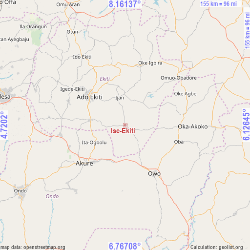
Ise-Ekiti GPS coordinates[2]
7° 27' 53.208" North, 5° 25' 23.988" East
| Map corner | latitude | longitude |
|---|---|---|
| Upper-left | 8.16137°, | 4.7202° |
| Center: | 7.46478°, | 5.42333° |
| Lower-right: | 6.76708°, | 6.12645° |
| Map W x H: | 155×155 km | = 96.3×96.3mi |
| max Lat: | 13.7543° ⇑62.4% North |
| Ise-Ekiti: | 7.46478° |
| min Lat: | ⇓37.6% South 4.31231° |
| min Long | Ise-Ekiti | max Long |
| 2.73333° | 5.42333° | 14.46552° |
| W 23.4%⇐ | ⇒76.6% E |
Elevation
Elevation of Ise-Ekiti is 379 m = 1243 ft, and this is 82.5 m = 271 ft above average elevation for this country.
| Max E: |
1599 m = 5246 ft | 33.3% |
| Ise-Ekiti | 379 m 1243 ft | |
| Avg. | 296.5 m = 973 ft | |
Min E: |
2 m = 7 ft | 66.7% |
See also: Ise-Ekiti elevation on elevation.city.
Geographical zone
Ise-Ekiti is located in North Torrid zone (between Equator and Tropic of Cancer). Distance of Equator is 830 km =515.7 mi to South.| Distance of | km | miles | from Ise-Ekiti |
|---|---|---|---|
| North Pole | 9177.1 | 5702.4 | to North |
| Arctic Circle | 6571.2 | 4083.2 | to North |
| Tropic Cancer | 1775.9 | 1103.5 | to North |
| Equator | 830 | 515.7 | to South |


Nearby cities:
15 places around Ise-Ekiti: (largest is in red/bold)
• Ado-Ekiti
28.4 km =17.6 mi,  308°
308°
• Akure
34.7 km =21.6 mi,  227°
227°
• Emure-Ekiti
5.1 km =3.2 mi,  128°
128°
• Igbara-Odo
40 km =24.9 mi,  276°
276°
• Igede-Ekiti
39.8 km =24.7 mi,  304°
304°
• Iju
19.7 km =12.2 mi,  246°
246°
• Ikare
37 km =23 mi,  79°
79°
• Ikere-Ekiti
21.6 km =13.4 mi, 279°
• Ikole-Ekiti
37.5 km =23.3 mi,  14°
14°
• Ilare
36.5 km =22.7 mi, 249°
• Ilawe-Ekiti
38.2 km =23.7 mi,  292°
292°
• Ita-Ogbolu
22.2 km =13.8 mi,  241°
241°
• Ode-Ekiti
24.7 km =15.3 mi,  34°
34°
• Owo
34.9 km =21.7 mi,  148°
148°
• Oye-Ekiti
38.6 km =24 mi,  344°
344°
Sources, notices
• [Note1] Compared only with cities in Nigeria existing in our database
• [Src1] Map data: © OpenStreetMap contributors (CC-BY-SA)
• [Src2] Other city data from geonames.org with taken over terms of usage.
• [Src3] Geographical zone / Annual Mean Temperature by Robert A. Rohde @ Wikipedia
