Ilawe-Ekiti geodata
Ilawe-Ekiti (Ekiti) is a seat of a second-order administrative division; located in Nigeria in Africa/Lagos (GMT+1) time zone. In our database, there are 451 cities with bigger population. Compared to other cities in Nigeria, 59.3% of cities are located further ↑North; 80.1% of cities are located further →East and 74.5% of cities have lower elevation than Ilawe-Ekiti. Note1


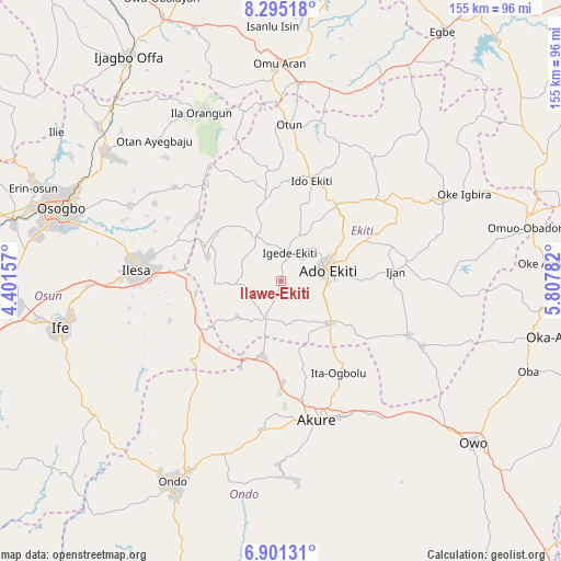
Ilawe-Ekiti GPS coordinates[2]
7° 35' 55.716" North, 5° 6' 16.92" East
| Map corner | latitude | longitude |
|---|---|---|
| Upper-left | 8.29518°, | 4.40157° |
| Center: | 7.59881°, | 5.1047° |
| Lower-right: | 6.90131°, | 5.80782° |
| Map W x H: | 155×155 km | = 96.3×96.3mi |
| max Lat: | 13.7543° ⇑59.3% North |
| Ilawe-Ekiti: | 7.59881° |
| min Lat: | ⇓40.7% South 4.31231° |
| min Long | Ilawe-Ekiti | max Long |
| 2.73333° | 5.1047° | 14.46552° |
| W 19.9%⇐ | ⇒80.1% E |
Elevation
Elevation of Ilawe-Ekiti is 426 m = 1398 ft, and this is 129.5 m = 425 ft above average elevation for this country.
| Max E: |
1599 m = 5246 ft | 25.5% |
| Ilawe-Ekiti | 426 m 1398 ft | |
| Avg. | 296.5 m = 973 ft | |
Min E: |
2 m = 7 ft | 74.5% |
See also: Nigeria elevation on elevation.city.
Geographical zone
Ilawe-Ekiti is located in North Torrid zone (between Equator and Tropic of Cancer). Distance of Equator is 844.9 km =525 mi to South.| Distance of | km | miles | from Ilawe-Ekiti |
|---|---|---|---|
| North Pole | 9162.2 | 5693.1 | to North |
| Arctic Circle | 6556.3 | 4073.9 | to North |
| Tropic Cancer | 1761 | 1094.2 | to North |
| Equator | 844.9 | 525 | to South |


Nearby cities:
15 places around Ilawe-Ekiti: (largest is in red/bold)
• Ado-Ekiti
13.1 km =8.1 mi,  77°
77°
• Aramoko-Ekiti
13.7 km =8.5 mi,  329°
329°
• Efon-Alaaye
21.1 km =13.1 mi,  287°
287°
• Ido-Ekiti
28.8 km =17.9 mi,  17°
17°
• Ifaki
26.5 km =16.5 mi,  36°
36°
• Igbara-Odo
11.7 km =7.3 mi,  203°
203°
• Igbara-Oke
21.4 km =13.3 mi,  193°
193°
• Igede-Ekiti
8.1 km =5 mi, 17°
• Ijero-Ekiti
24.4 km =15.2 mi,  350°
350°
• Iju
28.4 km =17.6 mi,  143°
143°
• Ikere-Ekiti
17.9 km =11.1 mi,  129°
129°
• Ilare
27.6 km =17.1 mi,  178°
178°
• Ipoti
30.7 km =19.1 mi, 354°
• Ita-Ogbolu
30 km =18.6 mi,  148°
148°
• Oke Mesi
31.9 km =19.8 mi,  319°
319°
Sources, notices
• [Note1] Compared only with cities in Nigeria existing in our database
• [Src1] Map data: © OpenStreetMap contributors (CC-BY-SA)
• [Src2] Other city data from geonames.org with taken over terms of usage.
• [Src3] Geographical zone / Annual Mean Temperature by Robert A. Rohde @ Wikipedia
