Ita-Ogbolu geodata
Ita-Ogbolu (Ondo) is a seat of a second-order administrative division; located in Nigeria in Africa/Lagos (GMT+1) time zone. In our database, there are 451 cities with bigger population. Compared to other cities in Nigeria, 64.1% of cities are located further ↑North; 77.9% of cities are located further →East and 60% of cities have lower elevation than Ita-Ogbolu. Note1


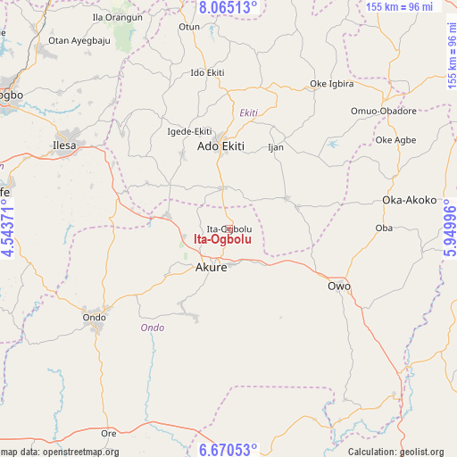
Ita-Ogbolu GPS coordinates[2]
7° 22' 6.168" North, 5° 14' 48.624" East
| Map corner | latitude | longitude |
|---|---|---|
| Upper-left | 8.06513°, | 4.54371° |
| Center: | 7.36838°, | 5.24684° |
| Lower-right: | 6.67053°, | 5.94996° |
| Map W x H: | 155.1×155.1 km | = 96.4×96.4mi |
| max Lat: | 13.7543° ⇑64.1% North |
| Ita-Ogbolu: | 7.36838° |
| min Lat: | ⇓35.9% South 4.31231° |
| min Long | Ita-Ogbolu | max Long |
| 2.73333° | 5.24684° | 14.46552° |
| W 22.1%⇐ | ⇒77.9% E |
Elevation
Elevation of Ita-Ogbolu is 346 m = 1135 ft, and this is 49.5 m = 162 ft above average elevation for this country.
| Max E: |
1599 m = 5246 ft | 40% |
| Ita-Ogbolu | 346 m 1135 ft | |
| Avg. | 296.5 m = 973 ft | |
Min E: |
2 m = 7 ft | 60% |
See also: Nigeria elevation on elevation.city.
Geographical zone
Ita-Ogbolu is located in North Torrid zone (between Equator and Tropic of Cancer). Distance of Equator is 819.3 km =509.1 mi to South.| Distance of | km | miles | from Ita-Ogbolu |
|---|---|---|---|
| North Pole | 9187.8 | 5709 | to North |
| Arctic Circle | 6581.9 | 4089.8 | to North |
| Tropic Cancer | 1786.6 | 1110.1 | to North |
| Equator | 819.3 | 509.1 | to South |


Nearby cities:
15 places around Ita-Ogbolu: (largest is in red/bold)
• Ado-Ekiti
28.5 km =17.7 mi,  354°
354°
• Akure
14.2 km =8.8 mi,  204°
204°
• Bolorunduro
38.5 km =23.9 mi,  234°
234°
• Emure-Ekiti
24.6 km =15.3 mi,  72°
72°
• Idanre
31.9 km =19.8 mi,  206°
206°
• Igbara-Odo
25.2 km =15.7 mi,  306°
306°
• Igbara-Oke
21.4 km =13.3 mi,  283°
283°
• Igede-Ekiti
35.9 km =22.3 mi,  338°
338°
• Iju
3.2 km =2 mi,  25°
25°
• Ikere-Ekiti
14.5 km =9 mi, 352°
• Ilare
14.9 km =9.3 mi,  262°
262°
• Ilawe-Ekiti
30 km =18.6 mi,  328°
328°
• Ise-Ekiti
22.2 km =13.8 mi,  61°
61°
• Owena
31.4 km =19.5 mi, 231°
• Owo
42.1 km =26.2 mi,  117°
117°
Sources, notices
• [Note1] Compared only with cities in Nigeria existing in our database
• [Src1] Map data: © OpenStreetMap contributors (CC-BY-SA)
• [Src2] Other city data from geonames.org with taken over terms of usage.
• [Src3] Geographical zone / Annual Mean Temperature by Robert A. Rohde @ Wikipedia
