Aba geodata
Aba (Abia) is a seat of a second-order administrative division; located in Nigeria in Africa/Lagos (GMT+1) time zone. With population of 897,560 people, there are 8 cities with bigger population in this country. Compared to other cities in Nigeria, 93.3% of cities are located further ↑North; 50.8% of cities are located further ←West and 84% of cities have higher elevation than Aba. Note1


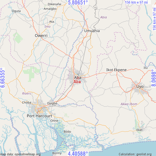
Aba GPS coordinates[2]
5° 6' 23.688" North, 7° 22' 0.012" East
| Map corner | latitude | longitude |
|---|---|---|
| Upper-left | 5.80651°, | 6.66355° |
| Center: | 5.10658°, | 7.36667° |
| Lower-right: | 4.40588°, | 8.0698° |
| Map W x H: | 155.7×155.7 km | = 96.7×96.7mi |
| max Lat: | 13.7543° ⇑93.3% North |
| Aba: | 5.10658° |
| min Lat: | ⇓6.7% South 4.31231° |
| min Long | Aba | max Long |
| 2.73333° | 7.36667° | 14.46552° |
| W 50.8%⇐ | ⇒49.2% E |
Elevation
Elevation of Aba is 64 m = 210 ft, and this is 232.5 m = 763 ft below average elevation for this country.
| Max E: |
1599 m = 5246 ft | 84% |
| Avg. | 296.5 m = 973 ft | |
| Aba | 64 m = 210 ft | |
Min E: |
2 m = 7 ft | 16% |
See also: Aba elevation on elevation.city.
Geographical zone
Aba is located in North Torrid zone (between Equator and Tropic of Cancer). Distance of Equator is 567.8 km =352.8 mi to South.| Distance of | km | miles | from Aba |
|---|---|---|---|
| North Pole | 9439.3 | 5865.3 | to North |
| Arctic Circle | 6833.4 | 4246.1 | to North |
| Tropic Cancer | 2038.1 | 1266.4 | to North |
| Equator | 567.8 | 352.8 | to South |


Nearby cities:
15 places around Aba: (largest is in red/bold)
• Afaha Ikot Ebak
32.2 km =20 mi,  86°
86°
• Afam
35.7 km =22.2 mi,  189°
189°
• Akwete
24.5 km =15.2 mi,  182°
182°
• Eberi
14.8 km =9.2 mi,  263°
263°
• Ikot Akpa Nkuk
34 km =21.1 mi,  139°
139°
• Ikot Ekpene
39.5 km =24.5 mi,  77°
77°
• Nto Edino
28.6 km =17.8 mi,  54°
54°
• Oke-Ikpe
22.2 km =13.8 mi, 193°
• Okehi
25.5 km =15.8 mi,  278°
278°
• Okpuala-Ngwa
28 km =17.4 mi,  4°
4°
• Omoba
15.8 km =9.8 mi,  16°
16°
• Osisioma
7.7 km =4.8 mi,  320°
320°
• Umuneke-Ngor
34.8 km =21.6 mi, 316°
• Urua Inyang
21.2 km =13.2 mi,  115°
115°
• Utu Etim Ekpo
29.3 km =18.2 mi,  112°
112°
Sources, notices
• [Note1] Compared only with cities in Nigeria existing in our database
• [Src1] Map data: © OpenStreetMap contributors (CC-BY-SA)
• [Src2] Other city data from geonames.org with taken over terms of usage.
• [Src3] Geographical zone / Annual Mean Temperature by Robert A. Rohde @ Wikipedia
