Okehi geodata
Okehi (Rivers) is a seat of a second-order administrative division; located in Nigeria in Africa/Lagos (GMT+1) time zone. In our database, there are 451 cities with bigger population. Compared to other cities in Nigeria, 92.7% of cities are located further ↑North; 53.4% of cities are located further →East and 86.9% of cities have higher elevation than Okehi. Note1


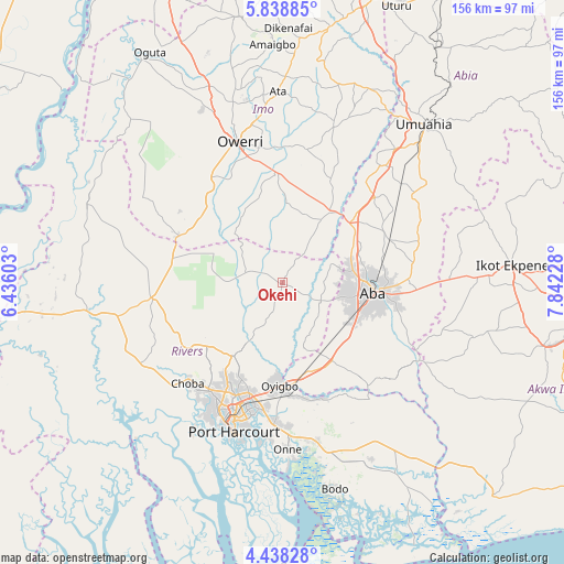
Okehi GPS coordinates[2]
5° 8' 20.22" North, 7° 8' 20.94" East
| Map corner | latitude | longitude |
|---|---|---|
| Upper-left | 5.83885°, | 6.43603° |
| Center: | 5.13895°, | 7.13915° |
| Lower-right: | 4.43828°, | 7.84228° |
| Map W x H: | 155.7×155.7 km | = 96.7×96.7mi |
| max Lat: | 13.7543° ⇑92.7% North |
| Okehi: | 5.13895° |
| min Lat: | ⇓7.3% South 4.31231° |
| min Long | Okehi | max Long |
| 2.73333° | 7.13915° | 14.46552° |
| W 46.6%⇐ | ⇒53.4% E |
Elevation
Elevation of Okehi is 51 m = 167 ft, and this is 245.5 m = 805 ft below average elevation for this country.
| Max E: |
1599 m = 5246 ft | 86.9% |
| Avg. | 296.5 m = 973 ft | |
| Okehi | 51 m = 167 ft | |
Min E: |
2 m = 7 ft | 13.1% |
See also: Nigeria elevation on elevation.city.
Geographical zone
Okehi is located in North Torrid zone (between Equator and Tropic of Cancer). Distance of Equator is 571.4 km =355.1 mi to South.| Distance of | km | miles | from Okehi |
|---|---|---|---|
| North Pole | 9435.7 | 5863.1 | to North |
| Arctic Circle | 6829.8 | 4243.8 | to North |
| Tropic Cancer | 2034.5 | 1264.2 | to North |
| Equator | 571.4 | 355.1 | to South |


Nearby cities:
15 places around Okehi: (largest is in red/bold)
• Aba
25.5 km =15.8 mi,  98°
98°
• Aboh
40.2 km =25 mi,  21°
21°
• Akwete
37 km =23 mi,  139°
139°
• Eberi
11.7 km =7.3 mi,  116°
116°
• Elele
36.2 km =22.5 mi,  263°
263°
• Isiokpo
33.2 km =20.6 mi,  242°
242°
• Nchia
38.5 km =23.9 mi,  183°
183°
• Oke-Ikpe
32.1 km =19.9 mi, 141°
• Okpuala-Ngwa
36.7 km =22.8 mi,  48°
48°
• Omoba
31.7 km =19.7 mi,  68°
68°
• Osisioma
20.4 km =12.7 mi,  83°
83°
• Owerri
40.1 km =24.9 mi,  342°
342°
• Rumuodomaya
31.2 km =19.4 mi,  209°
209°
• Umuguma
41.3 km =25.7 mi,  332°
332°
• Umuneke-Ngor
21.9 km =13.6 mi,  3°
3°
Sources, notices
• [Note1] Compared only with cities in Nigeria existing in our database
• [Src1] Map data: © OpenStreetMap contributors (CC-BY-SA)
• [Src2] Other city data from geonames.org with taken over terms of usage.
• [Src3] Geographical zone / Annual Mean Temperature by Robert A. Rohde @ Wikipedia
