Urua Inyang geodata
Urua Inyang (Akwa Ibom) is a seat of a second-order administrative division; located in Nigeria in Africa/Lagos (GMT+1) time zone. In our database, there are 451 cities with bigger population. Compared to other cities in Nigeria, 94.1% of cities are located further ↑North; 54.1% of cities are located further ←West and 83.5% of cities have higher elevation than Urua Inyang. Note1


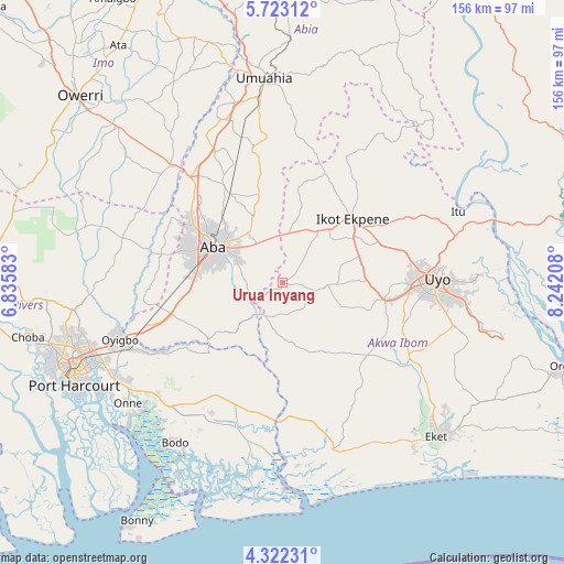
Urua Inyang GPS coordinates[2]
5° 1' 23.124" North, 7° 32' 20.22" East
| Map corner | latitude | longitude |
|---|---|---|
| Upper-left | 5.72312°, | 6.83583° |
| Center: | 5.02309°, | 7.53895° |
| Lower-right: | 4.32231°, | 8.24208° |
| Map W x H: | 155.8×155.8 km | = 96.8×96.8mi |
| max Lat: | 13.7543° ⇑94.1% North |
| Urua Inyang: | 5.02309° |
| min Lat: | ⇓5.9% South 4.31231° |
| min Long | Urua Inyang | max Long |
| 2.73333° | 7.53895° | 14.46552° |
| W 54.1%⇐ | ⇒45.9% E |
Elevation
Elevation of Urua Inyang is 65 m = 213 ft, and this is 231.5 m = 760 ft below average elevation for this country.
| Max E: |
1599 m = 5246 ft | 83.5% |
| Avg. | 296.5 m = 973 ft | |
| Urua Inyang | 65 m = 213 ft | |
Min E: |
2 m = 7 ft | 16.5% |
See also: Nigeria elevation on elevation.city.
Geographical zone
Urua Inyang is located in North Torrid zone (between Equator and Tropic of Cancer). Distance of Equator is 558.5 km =347 mi to South.| Distance of | km | miles | from Urua Inyang |
|---|---|---|---|
| North Pole | 9448.5 | 5871 | to North |
| Arctic Circle | 6842.7 | 4251.9 | to North |
| Tropic Cancer | 2047.4 | 1272.2 | to North |
| Equator | 558.5 | 347 | to South |


Nearby cities:
15 places around Urua Inyang: (largest is in red/bold)
• Aba
21.2 km =13.2 mi,  295°
295°
• Abak
28.1 km =17.5 mi,  99°
99°
• Afaha Ikot Ebak
17.3 km =10.7 mi,  49°
49°
• Afam
36.1 km =22.4 mi,  224°
224°
• Akwete
25.2 km =15.7 mi,  233°
233°
• Eberi
34.6 km =21.5 mi,  282°
282°
• Ibiaku Ntok Okpo
37 km =23 mi,  30°
30°
• Ikot Akpa Nkuk
17 km =10.6 mi,  170°
170°
• Ikot Ekpene
26.3 km =16.3 mi, 47°
• Ikot Ibritam
24.9 km =15.5 mi,  160°
160°
• Nto Edino
26.3 km =16.3 mi,  8°
8°
• Oke-Ikpe
27.2 km =16.9 mi,  243°
243°
• Omoba
28.5 km =17.7 mi,  328°
328°
• Osisioma
28.4 km =17.6 mi, 302°
• Utu Etim Ekpo
8.2 km =5.1 mi, 104°
Sources, notices
• [Note1] Compared only with cities in Nigeria existing in our database
• [Src1] Map data: © OpenStreetMap contributors (CC-BY-SA)
• [Src2] Other city data from geonames.org with taken over terms of usage.
• [Src3] Geographical zone / Annual Mean Temperature by Robert A. Rohde @ Wikipedia
