Waslala geodata
Waslala (North Caribbean Coast) is a populated place; located in Nicaragua in America/Managua (GMT-6) time zone. With population of 6,498 people, there are 63 cities with bigger population in this country. Compared to other cities in Nicaragua, 76.6% of cities are located further ↓South; 77.2% of cities are located further ←West and 53.9% of cities have lower elevation than Waslala. Note1


Waslala GPS coordinates[2]
13° 13' 59.988" North, 85° 22' 59.988" West
| Map corner | latitude | longitude |
|---|---|---|
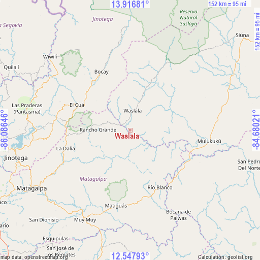
| Upper-left | 13.91681°, | -86.08646° |
| Center: | 13.23333°, | -85.38333° |
| Lower-right: | 12.54793°, | -84.68021° |
| Map W x H: | 152.2×152.2 km | = 94.6×94.6mi |
| max Lat: | 14.74189° ⇑23.4% North |
| Waslala: | 13.23333° |
| min Lat: | ⇓76.6% South 10.94684° |
| min Long | Waslala | max Long |
| -87.4516° | -85.38333° | -83.06145° |
| W 77.2%⇐ | ⇒22.8% E |
Elevation
Elevation of Waslala is 316 m = 1037 ft, and this is 21.2 m = 70 ft below average elevation for this country.
| Max E: |
1288 m = 4226 ft | 46.1% |
| Avg. | 337.2 m = 1106 ft | |
| Waslala | 316 m = 1037 ft | |
Min E: |
1 m = 3 ft | 53.9% |
See also: Nicaragua elevation on elevation.city.
Geographical zone
Waslala is located in North Torrid zone (between Equator and Tropic of Cancer). Distance of this Northern Tropic circle is 1134.5 km =704.9 mi to North.| Distance of | km | miles | from Waslala |
|---|---|---|---|
| North Pole | 8535.7 | 5303.8 | to North |
| Arctic Circle | 5929.8 | 3684.6 | to North |
| Tropic Cancer | 1134.5 | 704.9 | to North |
| Equator | 1471.4 | 914.3 | to South |


Nearby cities:
15 places around Waslala: (largest is in red/bold)
• Bocana de Paiwas
57.2 km =35.5 mi,  150°
150°
• El Cuá
34.8 km =21.6 mi,  295°
295°
• El Cuá
44.6 km =27.7 mi, 297°
• La Dalia
39.8 km =24.7 mi,  254°
254°
• Las Praderas
51 km =31.7 mi,  262°
262°
• Matiguás
44.9 km =27.9 mi,  190°
190°
• Mulukukú
46.8 km =29.1 mi,  97°
97°
• Muy Muy
58.8 km =36.5 mi,  206°
206°
• Rancho Grande
18.9 km =11.7 mi,  271°
271°
• Río Blanco
37.5 km =23.3 mi, 152°
• San José de Bocay
38.3 km =23.8 mi,  333°
333°
• San Ramón
60.2 km =37.4 mi,  235°
235°
• Santa Maía de Pantasma
62.1 km =38.6 mi,  281°
281°
• Waslala
11.5 km =7.1 mi,  6°
6°
• Wiwilí de Jinotega
63.2 km =39.3 mi,  312°
312°
Sources, notices
• [Note1] Compared only with cities in Nicaragua existing in our database
• [Src1] Map data: © OpenStreetMap contributors (CC-BY-SA)
• [Src2] Other city data from geonames.org with taken over terms of usage.
• [Src3] Geographical zone / Annual Mean Temperature by Robert A. Rohde @ Wikipedia
