El Cuá geodata
El Cuá (Jinotega) is a seat of a second-order administrative division; located in Nicaragua in America/Managua (GMT-6) time zone. In our database, there are 137 cities with bigger population. Compared to other cities in Nicaragua, 82% of cities are located further ↓South; 70.7% of cities are located further ←West and 65.3% of cities have lower elevation than El Cuá. Note1


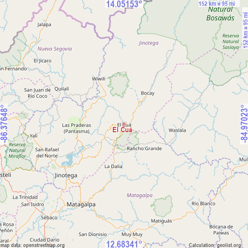
El Cuá GPS coordinates[2]
13° 22' 6.384" North, 85° 40' 24.06" West
| Map corner | latitude | longitude |
|---|---|---|
| Upper-left | 14.05153°, | -86.37648° |
| Center: | 13.36844°, | -85.67335° |
| Lower-right: | 12.68341°, | -84.97023° |
| Map W x H: | 152.1×152.1 km | = 94.5×94.5mi |
| max Lat: | 14.74189° ⇑18% North |
| El Cuá: | 13.36844° |
| min Lat: | ⇓82% South 10.94684° |
| min Long | El Cuá | max Long |
| -87.4516° | -85.67335° | -83.06145° |
| W 70.7%⇐ | ⇒29.3% E |
Elevation
Elevation of El Cuá is 439 m = 1440 ft, and this is 101.8 m = 334 ft above average elevation for this country.
| Max E: |
1288 m = 4226 ft | 34.7% |
| El Cuá | 439 m 1440 ft | |
| Avg. | 337.2 m = 1106 ft | |
Min E: |
1 m = 3 ft | 65.3% |
See also: Nicaragua elevation on elevation.city.
Geographical zone
El Cuá is located in North Torrid zone (between Equator and Tropic of Cancer). Distance of this Northern Tropic circle is 1119.5 km =695.6 mi to North.| Distance of | km | miles | from El Cuá |
|---|---|---|---|
| North Pole | 8520.6 | 5294.5 | to North |
| Arctic Circle | 5914.7 | 3675.2 | to North |
| Tropic Cancer | 1119.5 | 695.6 | to North |
| Equator | 1486.4 | 923.6 | to South |


Nearby cities:
15 places around El Cuá: (largest is in red/bold)
• El Cuá
9.9 km =6.2 mi,  302°
302°
• Jinotega
47.1 km =29.3 mi,  229°
229°
• LLano de La Cruz
45.3 km =28.1 mi, 233°
• La Dalia
26.7 km =16.6 mi,  195°
195°
• Las Praderas
29.2 km =18.1 mi,  220°
220°
• Quilalí
44.1 km =27.4 mi, 300°
• Rancho Grande
19.2 km =11.9 mi,  139°
139°
• San José de Bocay
24.1 km =15 mi,  36°
36°
• San Rafael del Norte
50.4 km =31.3 mi,  249°
249°
• Santa Maía de Pantasma
29.4 km =18.3 mi,  265°
265°
• Waslala
33 km =20.5 mi,  96°
96°
• Waslala
34.8 km =21.6 mi,  115°
115°
• Wiwili
32.3 km =20.1 mi,  329°
329°
• Wiwilí
33.1 km =20.6 mi, 330°
• Wiwilí de Jinotega
31.5 km =19.6 mi, 330°
Sources, notices
• [Note1] Compared only with cities in Nicaragua existing in our database
• [Src1] Map data: © OpenStreetMap contributors (CC-BY-SA)
• [Src2] Other city data from geonames.org with taken over terms of usage.
• [Src3] Geographical zone / Annual Mean Temperature by Robert A. Rohde @ Wikipedia
