Bocana de Paiwas geodata
Bocana de Paiwas (South Caribbean Coast) is a seat of a second-order administrative division; located in Nicaragua in America/Managua (GMT-6) time zone. With population of 7,872 people, there are 49 cities with bigger population in this country. Compared to other cities in Nicaragua, 58.1% of cities are located further ↓South; 82.6% of cities are located further ←West and 60.5% of cities have higher elevation than Bocana de Paiwas. Note1


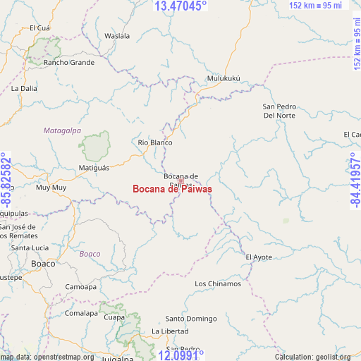
Bocana de Paiwas GPS coordinates[2]
12° 47' 8.556" North, 85° 7' 21.684" West
| Map corner | latitude | longitude |
|---|---|---|
| Upper-left | 13.47045°, | -85.82582° |
| Center: | 12.78571°, | -85.12269° |
| Lower-right: | 12.0991°, | -84.41957° |
| Map W x H: | 152.5×152.5 km | = 94.8×94.8mi |
| max Lat: | 14.74189° ⇑41.9% North |
| Bocana de Paiwas: | 12.78571° |
| min Lat: | ⇓58.1% South 10.94684° |
| min Long | Bocana de Paiwa | max Long |
| -87.4516° | -85.12269° | -83.06145° |
| W 82.6%⇐ | ⇒17.4% E |
Elevation
Elevation of Bocana de Paiwas is 146 m = 479 ft, and this is 191.2 m = 627 ft below average elevation for this country.
| Max E: |
1288 m = 4226 ft | 60.5% |
| Avg. | 337.2 m = 1106 ft | |
| Bocana de Paiwas | 146 m = 479 ft | |
Min E: |
1 m = 3 ft | 39.5% |
See also: Nicaragua elevation on elevation.city.
Geographical zone
Bocana de Paiwas is located in North Torrid zone (between Equator and Tropic of Cancer). Distance of this Northern Tropic circle is 1184.3 km =735.9 mi to North.| Distance of | km | miles | from Bocana de Paiwas |
|---|---|---|---|
| North Pole | 8585.4 | 5334.7 | to North |
| Arctic Circle | 5979.5 | 3715.5 | to North |
| Tropic Cancer | 1184.3 | 735.9 | to North |
| Equator | 1421.6 | 883.3 | to South |


Nearby cities:
15 places around Bocana de Paiwas: (largest is in red/bold)
• Boaco
67.8 km =42.1 mi,  239°
239°
• Camoapa
61.6 km =38.3 mi,  223°
223°
• Cuapa
64 km =39.8 mi,  206°
206°
• El Ayote
46.1 km =28.6 mi,  133°
133°
• El Ayote
68.6 km =42.6 mi,  195°
195°
• La Libertad
63.5 km =39.5 mi,  184°
184°
• Matiguás
37.3 km =23.2 mi,  278°
278°
• Mulukukú
47 km =29.2 mi,  22°
22°
• Muy Muy
55 km =34.2 mi,  267°
267°
• Rancho Grande
68.9 km =42.8 mi,  316°
316°
• Río Blanco
19.8 km =12.3 mi,  326°
326°
• Santa Lucía
69.7 km =43.3 mi,  246°
246°
• Santo Domingo
58.1 km =36.1 mi, 175°
• Waslala
57.2 km =35.5 mi, 330°
• Waslala
66.8 km =41.5 mi,  336°
336°
Sources, notices
• [Note1] Compared only with cities in Nicaragua existing in our database
• [Src1] Map data: © OpenStreetMap contributors (CC-BY-SA)
• [Src2] Other city data from geonames.org with taken over terms of usage.
• [Src3] Geographical zone / Annual Mean Temperature by Robert A. Rohde @ Wikipedia
