Quilalí geodata
Quilalí (Nueva Segovia) is a seat of a second-order administrative division; located in Nicaragua in America/Managua (GMT-6) time zone. With population of 13,590 people, there are 37 cities with bigger population in this country. Compared to other cities in Nicaragua, 89.2% of cities are located further ↓South; 53.3% of cities are located further ←West and 63.5% of cities have lower elevation than Quilalí. Note1


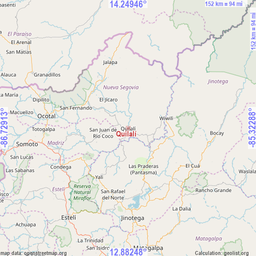
Quilalí GPS coordinates[2]
13° 34' 1.02" North, 86° 1' 33.6" West
| Map corner | latitude | longitude |
|---|---|---|
| Upper-left | 14.24946°, | -86.72913° |
| Center: | 13.56695°, | -86.026° |
| Lower-right: | 12.88248°, | -85.32288° |
| Map W x H: | 152×152 km | = 94.4×94.4mi |
| max Lat: | 14.74189° ⇑10.8% North |
| Quilalí: | 13.56695° |
| min Lat: | ⇓89.2% South 10.94684° |
| min Long | Quilalí | max Long |
| -87.4516° | -86.026° | -83.06145° |
| W 53.3%⇐ | ⇒46.7% E |
Elevation
Elevation of Quilalí is 412 m = 1352 ft, and this is 74.8 m = 245 ft above average elevation for this country.
| Max E: |
1288 m = 4226 ft | 36.5% |
| Quilalí | 412 m 1352 ft | |
| Avg. | 337.2 m = 1106 ft | |
Min E: |
1 m = 3 ft | 63.5% |
See also: Nicaragua elevation on elevation.city.
Geographical zone
Quilalí is located in North Torrid zone (between Equator and Tropic of Cancer). Distance of this Northern Tropic circle is 1097.4 km =681.9 mi to North.| Distance of | km | miles | from Quilalí |
|---|---|---|---|
| North Pole | 8498.6 | 5280.8 | to North |
| Arctic Circle | 5892.7 | 3661.6 | to North |
| Tropic Cancer | 1097.4 | 681.9 | to North |
| Equator | 1508.5 | 937.3 | to South |


Nearby cities:
15 places around Quilalí: (largest is in red/bold)
• Ciudad Antigua
31.6 km =19.6 mi,  285°
285°
• El Cuá
34.2 km =21.3 mi,  119°
119°
• El Jícaro
21.2 km =13.2 mi,  324°
324°
• Jalapa
40.9 km =25.4 mi,  345°
345°
• Murra
21.3 km =13.2 mi,  2°
2°
• Palacagüina
42.9 km =26.7 mi,  253°
253°
• San Fernando
33.5 km =20.8 mi, 291°
• San Juan de Río Coco
15.2 km =9.4 mi,  260°
260°
• San Rafael del Norte
40.5 km =25.2 mi,  193°
193°
• San Sebastián de Yalí
33.9 km =21.1 mi,  210°
210°
• Santa Maía de Pantasma
25.9 km =16.1 mi,  160°
160°
• Telpaneca
28.5 km =17.7 mi, 262°
• Wiwili
22.5 km =14 mi,  75°
75°
• Wiwilí
22.7 km =14.1 mi,  72°
72°
• Wiwilí de Jinotega
23.2 km =14.4 mi, 76°
Sources, notices
• [Note1] Compared only with cities in Nicaragua existing in our database
• [Src1] Map data: © OpenStreetMap contributors (CC-BY-SA)
• [Src2] Other city data from geonames.org with taken over terms of usage.
• [Src3] Geographical zone / Annual Mean Temperature by Robert A. Rohde @ Wikipedia
