Murra geodata
Murra (Nueva Segovia) is a seat of a second-order administrative division; located in Nicaragua in America/Managua (GMT-6) time zone. With population of 1,179 people, there are 125 cities with bigger population in this country. Compared to other cities in Nicaragua, 97% of cities are located further ↓South; 53.9% of cities are located further ←West and 91% of cities have lower elevation than Murra. Note1


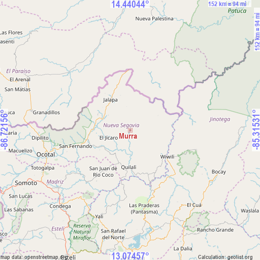
Murra GPS coordinates[2]
13° 45' 30.6" North, 86° 1' 6.348" West
| Map corner | latitude | longitude |
|---|---|---|
| Upper-left | 14.44044°, | -86.72156° |
| Center: | 13.7585°, | -86.01843° |
| Lower-right: | 13.07457°, | -85.31531° |
| Map W x H: | 151.9×151.9 km | = 94.4×94.4mi |
| max Lat: | 14.74189° ⇑3% North |
| Murra: | 13.7585° |
| min Lat: | ⇓97% South 10.94684° |
| min Long | Murra | max Long |
| -87.4516° | -86.01843° | -83.06145° |
| W 53.9%⇐ | ⇒46.1% E |
Elevation
Elevation of Murra is 776 m = 2546 ft, and this is 438.8 m = 1440 ft above average elevation for this country.
| Max E: |
1288 m = 4226 ft | 9% |
| Murra | 776 m 2546 ft | |
| Avg. | 337.2 m = 1106 ft | |
Min E: |
1 m = 3 ft | 91% |
See also: Nicaragua elevation on elevation.city.
Geographical zone
Murra is located in North Torrid zone (between Equator and Tropic of Cancer). Distance of this Northern Tropic circle is 1076.1 km =668.7 mi to North.| Distance of | km | miles | from Murra |
|---|---|---|---|
| North Pole | 8477.3 | 5267.5 | to North |
| Arctic Circle | 5871.4 | 3648.3 | to North |
| Tropic Cancer | 1076.1 | 668.7 | to North |
| Equator | 1529.8 | 950.6 | to South |


Nearby cities:
15 places around Murra: (largest is in red/bold)
• Ciudad Antigua
33.9 km =21.1 mi,  247°
247°
• Dipilto
52.8 km =32.8 mi,  265°
265°
• El Cuá
47.8 km =29.7 mi,  142°
142°
• El Jícaro
13.6 km =8.5 mi, 253°
• Jalapa
21.4 km =13.3 mi,  328°
328°
• Mozonte
46.7 km =29 mi,  256°
256°
• Ocotal
51.3 km =31.9 mi, 254°
• Quilalí
21.3 km =13.2 mi,  182°
182°
• San Fernando
33.3 km =20.7 mi, 254°
• San Juan de Río Coco
28.6 km =17.8 mi,  213°
213°
• Santa Maía de Pantasma
46.3 km =28.8 mi,  170°
170°
• Telpaneca
38.5 km =23.9 mi,  228°
228°
• Wiwili
26 km =16.2 mi,  126°
126°
• Wiwilí
25.5 km =15.8 mi, 125°
• Wiwilí de Jinotega
27 km =16.8 mi, 126°
Sources, notices
• [Note1] Compared only with cities in Nicaragua existing in our database
• [Src1] Map data: © OpenStreetMap contributors (CC-BY-SA)
• [Src2] Other city data from geonames.org with taken over terms of usage.
• [Src3] Geographical zone / Annual Mean Temperature by Robert A. Rohde @ Wikipedia
