Palacagüina geodata
Palacagüina (Madriz) is a seat of a second-order administrative division; located in Nicaragua in America/Managua (GMT-6) time zone. With population of 3,678 people, there are 89 cities with bigger population in this country. Compared to other cities in Nicaragua, 85% of cities are located further ↓South; 74.9% of cities are located further →East and 76.6% of cities have lower elevation than Palacagüina. Note1


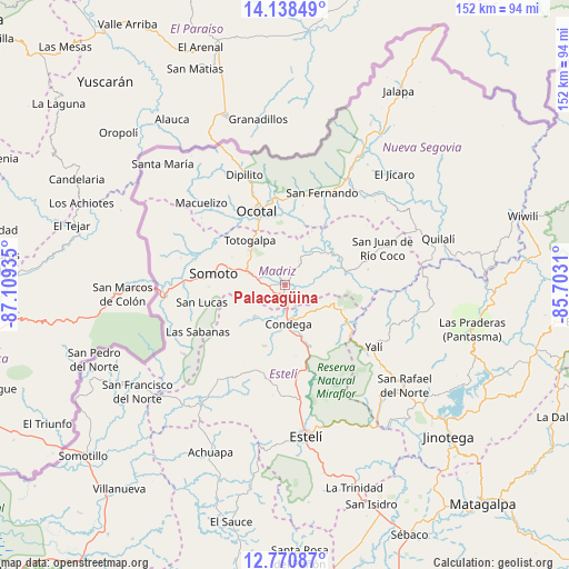
Palacagüina GPS coordinates[2]
13° 27' 20.376" North, 86° 24' 22.392" West
| Map corner | latitude | longitude |
|---|---|---|
| Upper-left | 14.13849°, | -87.10935° |
| Center: | 13.45566°, | -86.40622° |
| Lower-right: | 12.77087°, | -85.7031° |
| Map W x H: | 152.1×152.1 km | = 94.5×94.5mi |
| max Lat: | 14.74189° ⇑15% North |
| Palacagüina: | 13.45566° |
| min Lat: | ⇓85% South 10.94684° |
| min Long | Palacagüina | max Long |
| -87.4516° | -86.40622° | -83.06145° |
| W 25.1%⇐ | ⇒74.9% E |
Elevation
Elevation of Palacagüina is 545 m = 1788 ft, and this is 207.8 m = 682 ft above average elevation for this country.
| Max E: |
1288 m = 4226 ft | 23.4% |
| Palacagüina | 545 m 1788 ft | |
| Avg. | 337.2 m = 1106 ft | |
Min E: |
1 m = 3 ft | 76.6% |
See also: Nicaragua elevation on elevation.city.
Geographical zone
Palacagüina is located in North Torrid zone (between Equator and Tropic of Cancer). Distance of this Northern Tropic circle is 1109.8 km =689.6 mi to North.| Distance of | km | miles | from Palacagüina |
|---|---|---|---|
| North Pole | 8510.9 | 5288.4 | to North |
| Arctic Circle | 5905 | 3669.2 | to North |
| Tropic Cancer | 1109.8 | 689.6 | to North |
| Equator | 1496.1 | 929.6 | to South |


Nearby cities:
15 places around Palacagüina: (largest is in red/bold)
• Ciudad Antigua
23.1 km =14.4 mi,  27°
27°
• Condega
10.1 km =6.3 mi,  175°
175°
• Las Sabanas
26.5 km =16.5 mi,  241°
241°
• Macuelizo
31.3 km =19.4 mi,  314°
314°
• Mozonte
23 km =14.3 mi,  351°
351°
• Ocotal
21 km =13 mi,  339°
339°
• Pueblo Nuevo
11.7 km =7.3 mi,  223°
223°
• San Fernando
26.6 km =16.5 mi,  21°
21°
• San Juan de Río Coco
27.9 km =17.3 mi,  69°
69°
• San Lucas
22.6 km =14 mi,  258°
258°
• San Sebastián de Yalí
29.1 km =18.1 mi,  125°
125°
• Somoto
19.2 km =11.9 mi,  278°
278°
• Telpaneca
15.4 km =9.6 mi,  56°
56°
• Totogalpa
15.1 km =9.4 mi,  321°
321°
• Yalagüina
9.9 km =6.2 mi,  288°
288°
Sources, notices
• [Note1] Compared only with cities in Nicaragua existing in our database
• [Src1] Map data: © OpenStreetMap contributors (CC-BY-SA)
• [Src2] Other city data from geonames.org with taken over terms of usage.
• [Src3] Geographical zone / Annual Mean Temperature by Robert A. Rohde @ Wikipedia
