San Sebastián de Yalí geodata
San Sebastián de Yalí (Jinotega) is a seat of a second-order administrative division; located in Nicaragua in America/Managua (GMT-6) time zone. With population of 4,514 people, there are 80 cities with bigger population in this country. Compared to other cities in Nicaragua, 79% of cities are located further ↓South; 59.9% of cities are located further →East and 94% of cities have lower elevation than San Sebastián de Yalí. Note1


San Sebastián de Yalí GPS coordinates[2]
13° 18' 19.44" North, 86° 11' 11.076" West
| Map corner | latitude | longitude |
|---|---|---|
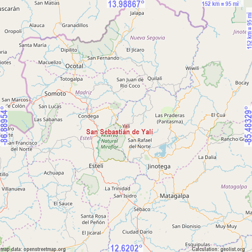
| Upper-left | 13.98867°, | -86.88954° |
| Center: | 13.3054°, | -86.18641° |
| Lower-right: | 12.6202°, | -85.48329° |
| Map W x H: | 152.2×152.2 km | = 94.6×94.6mi |
| max Lat: | 14.74189° ⇑21% North |
| San Sebastián de Yalí: | 13.3054° |
| min Lat: | ⇓79% South 10.94684° |
| min Long | San Sebastián | max Long |
| -87.4516° | -86.18641° | -83.06145° |
| W 40.1%⇐ | ⇒59.9% E |
Elevation
Elevation of San Sebastián de Yalí is 855 m = 2805 ft, and this is 517.8 m = 1699 ft above average elevation for this country.
| Max E: |
1288 m = 4226 ft | 6% |
| San Sebastián de Yalí | 855 m 2805 ft | |
| Avg. | 337.2 m = 1106 ft | |
Min E: |
1 m = 3 ft | 94% |
See also: Nicaragua elevation on elevation.city.
Geographical zone
San Sebastián de Yalí is located in North Torrid zone (between Equator and Tropic of Cancer). Distance of this Northern Tropic circle is 1126.5 km =700 mi to North.| Distance of | km | miles | from San Sebastián de Yalí |
|---|---|---|---|
| North Pole | 8527.6 | 5298.8 | to North |
| Arctic Circle | 5921.8 | 3679.6 | to North |
| Tropic Cancer | 1126.5 | 700 | to North |
| Equator | 1479.4 | 919.3 | to South |


Nearby cities:
15 places around San Sebastián de Yalí: (largest is in red/bold)
• Condega
23.9 km =14.9 mi,  286°
286°
• Estelí
29.9 km =18.6 mi,  217°
217°
• Jinotega
31.1 km =19.3 mi,  140°
140°
• LLano de La Cruz
27.9 km =17.3 mi, 136°
• La Concordia
12.4 km =7.7 mi,  170°
170°
• La Trinidad
37.8 km =23.5 mi,  188°
188°
• Las Praderas
39.4 km =24.5 mi,  112°
112°
• Palacagüina
29.1 km =18.1 mi,  305°
305°
• Pueblo Nuevo
32.9 km =20.4 mi,  284°
284°
• Quilalí
33.9 km =21.1 mi,  30°
30°
• San Juan de Río Coco
26.7 km =16.6 mi,  4°
4°
• San Rafael del Norte
13.2 km =8.2 mi, 141°
• Santa Maía de Pantasma
26.6 km =16.5 mi,  79°
79°
• Telpaneca
27.4 km =17 mi,  336°
336°
• Yalagüina
38.6 km =24 mi,  300°
300°
Sources, notices
• [Note1] Compared only with cities in Nicaragua existing in our database
• [Src1] Map data: © OpenStreetMap contributors (CC-BY-SA)
• [Src2] Other city data from geonames.org with taken over terms of usage.
• [Src3] Geographical zone / Annual Mean Temperature by Robert A. Rohde @ Wikipedia
