Nandasmo geodata
Nandasmo (Masaya) is a seat of a second-order administrative division; located in Nicaragua in America/Managua (GMT-6) time zone. With population of 6,934 people, there are 61 cities with bigger population in this country. Compared to other cities in Nicaragua, 77.2% of cities are located further ↑North; 53.3% of cities are located further →East and 64.7% of cities have lower elevation than Nandasmo. Note1


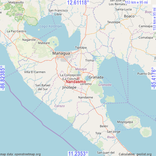
Nandasmo GPS coordinates[2]
11° 55' 26.796" North, 86° 7' 14.592" West
| Map corner | latitude | longitude |
|---|---|---|
| Upper-left | 12.61118°, | -86.82385° |
| Center: | 11.92411°, | -86.12072° |
| Lower-right: | 11.2353°, | -85.4176° |
| Map W x H: | 153×153 km | = 95.1×95.1mi |
| max Lat: | 14.74189° ⇑77.2% North |
| Nandasmo: | 11.92411° |
| min Lat: | ⇓22.8% South 10.94684° |
| min Long | Nandasmo | max Long |
| -87.4516° | -86.12072° | -83.06145° |
| W 46.7%⇐ | ⇒53.3% E |
Elevation
Elevation of Nandasmo is 425 m = 1394 ft, and this is 87.8 m = 288 ft above average elevation for this country.
| Max E: |
1288 m = 4226 ft | 35.3% |
| Nandasmo | 425 m 1394 ft | |
| Avg. | 337.2 m = 1106 ft | |
Min E: |
1 m = 3 ft | 64.7% |
See also: Nicaragua elevation on elevation.city.
Geographical zone
Nandasmo is located in North Torrid zone (between Equator and Tropic of Cancer). Distance of this Northern Tropic circle is 1280.1 km =795.4 mi to North.| Distance of | km | miles | from Nandasmo |
|---|---|---|---|
| North Pole | 8681.2 | 5394.2 | to North |
| Arctic Circle | 6075.3 | 3775 | to North |
| Tropic Cancer | 1280.1 | 795.4 | to North |
| Equator | 1325.8 | 823.8 | to South |


Nearby cities:
15 places around Nandasmo: (largest is in red/bold)
• Catarina
5.3 km =3.3 mi,  104°
104°
• Diriomo
9.2 km =5.7 mi,  125°
125°
• Diriá
8.4 km =5.2 mi,  121°
121°
• Dolores
12.7 km =7.9 mi,  234°
234°
• El Rosario
11.3 km =7 mi,  205°
205°
• Jinotepe
11.9 km =7.4 mi, 225°
• La Concepción
7.6 km =4.7 mi,  280°
280°
• La Paz de Carazo
11.3 km =7 mi,  183°
183°
• Masatepe
2.8 km =1.7 mi,  247°
247°
• Masaya
6.3 km =3.9 mi,  27°
27°
• Nindirí
8.9 km =5.5 mi,  359°
359°
• Niquinohomo
3.5 km =2.2 mi, 126°
• San Juan de Oriente
5.5 km =3.4 mi,  111°
111°
• San Marcos
9.2 km =5.7 mi,  259°
259°
• Santa Teresa
14.2 km =8.8 mi,  198°
198°
Sources, notices
• [Note1] Compared only with cities in Nicaragua existing in our database
• [Src1] Map data: © OpenStreetMap contributors (CC-BY-SA)
• [Src2] Other city data from geonames.org with taken over terms of usage.
• [Src3] Geographical zone / Annual Mean Temperature by Robert A. Rohde @ Wikipedia
