Jinotepe geodata
Jinotepe (Carazo) is a seat of a first-order administrative division; located in Nicaragua in America/Managua (GMT-6) time zone. With population of 29,507 people, there are 20 cities with bigger population in this country. Compared to other cities in Nicaragua, 83.8% of cities are located further ↑North; 62.3% of cities are located further →East and 79% of cities have lower elevation than Jinotepe. Note1


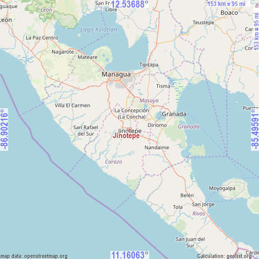
Jinotepe GPS coordinates[2]
11° 50' 58.632" North, 86° 11' 56.508" West
| Map corner | latitude | longitude |
|---|---|---|
| Upper-left | 12.53688°, | -86.90216° |
| Center: | 11.84962°, | -86.19903° |
| Lower-right: | 11.16063°, | -85.49591° |
| Map W x H: | 153×153 km | = 95.1×95.1mi |
| max Lat: | 14.74189° ⇑83.8% North |
| Jinotepe: | 11.84962° |
| min Lat: | ⇓16.2% South 10.94684° |
| min Long | Jinotepe | max Long |
| -87.4516° | -86.19903° | -83.06145° |
| W 37.7%⇐ | ⇒62.3% E |
Elevation
Elevation of Jinotepe is 569 m = 1867 ft, and this is 231.8 m = 760 ft above average elevation for this country.
| Max E: |
1288 m = 4226 ft | 21% |
| Jinotepe | 569 m 1867 ft | |
| Avg. | 337.2 m = 1106 ft | |
Min E: |
1 m = 3 ft | 79% |
See also: Nicaragua elevation on elevation.city.
Geographical zone
Jinotepe is located in North Torrid zone (between Equator and Tropic of Cancer). Distance of this Northern Tropic circle is 1288.4 km =800.6 mi to North.| Distance of | km | miles | from Jinotepe |
|---|---|---|---|
| North Pole | 8689.5 | 5399.4 | to North |
| Arctic Circle | 6083.6 | 3780.2 | to North |
| Tropic Cancer | 1288.4 | 800.6 | to North |
| Equator | 1317.6 | 818.7 | to South |


Nearby cities:
15 places around Jinotepe: (largest is in red/bold)
• Catarina
15.3 km =9.5 mi,  63°
63°
• Diriamba
4.5 km =2.8 mi,  282°
282°
• Diriá
16.1 km =10 mi,  76°
76°
• Dolores
2 km =1.2 mi,  293°
293°
• El Rosario
4.1 km =2.5 mi,  116°
116°
• La Concepción
9.8 km =6.1 mi,  5°
5°
• La Conquista
12.8 km =8 mi,  176°
176°
• La Paz de Carazo
8.3 km =5.2 mi,  110°
110°
• Masatepe
9.3 km =5.8 mi,  39°
39°
• Nandasmo
11.9 km =7.4 mi,  45°
45°
• Niquinohomo
12.9 km =8 mi, 61°
• San Juan de Oriente
15 km =9.3 mi,  65°
65°
• San Marcos
6.7 km =4.2 mi,  355°
355°
• Santa Teresa
6.5 km =4 mi,  142°
142°
• Santa Teresa
11.9 km =7.4 mi,  187°
187°
Sources, notices
• [Note1] Compared only with cities in Nicaragua existing in our database
• [Src1] Map data: © OpenStreetMap contributors (CC-BY-SA)
• [Src2] Other city data from geonames.org with taken over terms of usage.
• [Src3] Geographical zone / Annual Mean Temperature by Robert A. Rohde @ Wikipedia
