Masatepe geodata
Masatepe (Masaya) is a seat of a second-order administrative division; located in Nicaragua in America/Managua (GMT-6) time zone. With population of 21,452 people, there are 26 cities with bigger population in this country. Compared to other cities in Nicaragua, 78.4% of cities are located further ↑North; 56.9% of cities are located further →East and 65.9% of cities have lower elevation than Masatepe. Note1


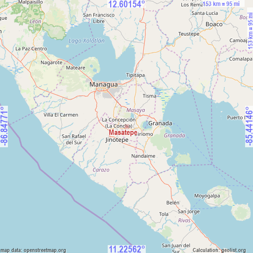
Masatepe GPS coordinates[2]
11° 54' 52.02" North, 86° 8' 40.488" West
| Map corner | latitude | longitude |
|---|---|---|
| Upper-left | 12.60154°, | -86.84771° |
| Center: | 11.91445°, | -86.14458° |
| Lower-right: | 11.22562°, | -85.44146° |
| Map W x H: | 153×153 km | = 95.1×95.1mi |
| max Lat: | 14.74189° ⇑78.4% North |
| Masatepe: | 11.91445° |
| min Lat: | ⇓21.6% South 10.94684° |
| min Long | Masatepe | max Long |
| -87.4516° | -86.14458° | -83.06145° |
| W 43.1%⇐ | ⇒56.9% E |
Elevation
Elevation of Masatepe is 454 m = 1490 ft, and this is 116.8 m = 383 ft above average elevation for this country.
| Max E: |
1288 m = 4226 ft | 34.1% |
| Masatepe | 454 m 1490 ft | |
| Avg. | 337.2 m = 1106 ft | |
Min E: |
1 m = 3 ft | 65.9% |
See also: Nicaragua elevation on elevation.city.
Geographical zone
Masatepe is located in North Torrid zone (between Equator and Tropic of Cancer). Distance of this Northern Tropic circle is 1281.2 km =796.1 mi to North.| Distance of | km | miles | from Masatepe |
|---|---|---|---|
| North Pole | 8682.3 | 5394.9 | to North |
| Arctic Circle | 6076.4 | 3775.7 | to North |
| Tropic Cancer | 1281.2 | 796.1 | to North |
| Equator | 1324.8 | 823.2 | to South |


Nearby cities:
15 places around Masatepe: (largest is in red/bold)
• Catarina
7.7 km =4.8 mi,  92°
92°
• Diriamba
12.1 km =7.5 mi,  238°
238°
• Diriomo
10.9 km =6.8 mi,  112°
112°
• Diriá
10.3 km =6.4 mi, 109°
• Dolores
10 km =6.2 mi,  230°
230°
• El Rosario
9.4 km =5.8 mi,  193°
193°
• Jinotepe
9.3 km =5.8 mi,  219°
219°
• La Concepción
5.5 km =3.4 mi,  297°
297°
• La Paz de Carazo
10.3 km =6.4 mi,  169°
169°
• Masaya
8.6 km =5.3 mi,  39°
39°
• Nandasmo
2.8 km =1.7 mi,  67°
67°
• Nindirí
10.3 km =6.4 mi,  14°
14°
• Niquinohomo
5.5 km =3.4 mi,  100°
100°
• San Juan de Oriente
7.8 km =4.8 mi, 96°
• San Marcos
6.4 km =4 mi,  265°
265°
Sources, notices
• [Note1] Compared only with cities in Nicaragua existing in our database
• [Src1] Map data: © OpenStreetMap contributors (CC-BY-SA)
• [Src2] Other city data from geonames.org with taken over terms of usage.
• [Src3] Geographical zone / Annual Mean Temperature by Robert A. Rohde @ Wikipedia
