Masaya geodata
Masaya is a seat of a first-order administrative division; located in Nicaragua in America/Managua (GMT-6) time zone. With population of 130,113 people, there are 2 cities with bigger population in this country. Compared to other cities in Nicaragua, 74.9% of cities are located further ↑North; 50.3% of cities are located further →East and 52.7% of cities have higher elevation than Masaya. Note1


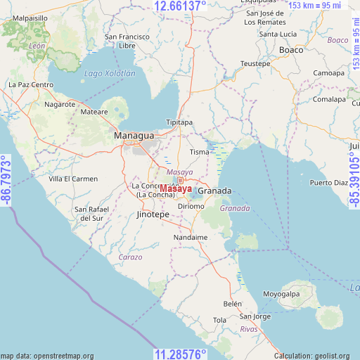
Masaya GPS coordinates[2]
11° 58' 27.984" North, 86° 5' 39.012" West
| Map corner | latitude | longitude |
|---|---|---|
| Upper-left | 12.66137°, | -86.7973° |
| Center: | 11.97444°, | -86.09417° |
| Lower-right: | 11.28576°, | -85.39105° |
| Map W x H: | 153×153 km | = 95.1×95.1mi |
| max Lat: | 14.74189° ⇑74.9% North |
| Masaya: | 11.97444° |
| min Lat: | ⇓25.1% South 10.94684° |
| min Long | Masaya | max Long |
| -87.4516° | -86.09417° | -83.06145° |
| W 49.7%⇐ | ⇒50.3% E |
Elevation
Elevation of Masaya is 239 m = 784 ft, and this is 98.2 m = 322 ft below average elevation for this country.
| Max E: |
1288 m = 4226 ft | 52.7% |
| Avg. | 337.2 m = 1106 ft | |
| Masaya | 239 m = 784 ft | |
Min E: |
1 m = 3 ft | 47.3% |
See also: Masaya elevation on elevation.city.
Geographical zone
Masaya is located in North Torrid zone (between Equator and Tropic of Cancer). Distance of this Northern Tropic circle is 1274.5 km =791.9 mi to North.| Distance of | km | miles | from Masaya |
|---|---|---|---|
| North Pole | 8675.6 | 5390.8 | to North |
| Arctic Circle | 6069.7 | 3771.5 | to North |
| Tropic Cancer | 1274.5 | 791.9 | to North |
| Equator | 1331.4 | 827.3 | to South |


Nearby cities:
15 places around Masaya: (largest is in red/bold)
• Catarina
7.3 km =4.5 mi,  162°
162°
• Diriomo
11.8 km =7.3 mi, 157°
• Diriá
10.9 km =6.8 mi, 157°
• El Rosario
17.5 km =10.9 mi,  206°
206°
• Granada
15.8 km =9.8 mi,  108°
108°
• La Concepción
11.2 km =7 mi,  248°
248°
• La Paz de Carazo
17.2 km =10.7 mi,  192°
192°
• Masatepe
8.6 km =5.3 mi,  219°
219°
• Nandasmo
6.3 km =3.9 mi, 207°
• Nindirí
4.4 km =2.7 mi,  317°
317°
• Niquinohomo
7.7 km =4.8 mi,  180°
180°
• San Juan de Oriente
7.9 km =4.9 mi, 163°
• San Marcos
13.9 km =8.6 mi,  238°
238°
• Ticuantepe
13.2 km =8.2 mi,  293°
293°
• Tisma
14.6 km =9.1 mi,  34°
34°
Sources, notices
• [Note1] Compared only with cities in Nicaragua existing in our database
• [Src1] Map data: © OpenStreetMap contributors (CC-BY-SA)
• [Src2] Other city data from geonames.org with taken over terms of usage.
• [Src3] Geographical zone / Annual Mean Temperature by Robert A. Rohde @ Wikipedia
