Dipilto geodata
Dipilto (Nueva Segovia) is a seat of a second-order administrative division; located in Nicaragua in America/Managua (GMT-6) time zone. With population of 467 people, there are 134 cities with bigger population in this country. Compared to other cities in Nicaragua, 94.6% of cities are located further ↓South; 80.2% of cities are located further →East and 95.2% of cities have lower elevation than Dipilto. Note1


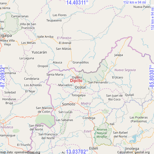
Dipilto GPS coordinates[2]
13° 43' 15.816" North, 86° 30' 22.284" West
| Map corner | latitude | longitude |
|---|---|---|
| Upper-left | 14.40311°, | -87.20932° |
| Center: | 13.72106°, | -86.50619° |
| Lower-right: | 13.03702°, | -85.80307° |
| Map W x H: | 151.9×151.9 km | = 94.4×94.4mi |
| max Lat: | 14.74189° ⇑5.4% North |
| Dipilto: | 13.72106° |
| min Lat: | ⇓94.6% South 10.94684° |
| min Long | Dipilto | max Long |
| -87.4516° | -86.50619° | -83.06145° |
| W 19.8%⇐ | ⇒80.2% E |
Elevation
Elevation of Dipilto is 917 m = 3009 ft, and this is 579.8 m = 1902 ft above average elevation for this country.
| Max E: |
1288 m = 4226 ft | 4.8% |
| Dipilto | 917 m 3009 ft | |
| Avg. | 337.2 m = 1106 ft | |
Min E: |
1 m = 3 ft | 95.2% |
See also: Nicaragua elevation on elevation.city.
Geographical zone
Dipilto is located in North Torrid zone (between Equator and Tropic of Cancer). Distance of this Northern Tropic circle is 1080.3 km =671.3 mi to North.| Distance of | km | miles | from Dipilto |
|---|---|---|---|
| North Pole | 8481.4 | 5270.1 | to North |
| Arctic Circle | 5875.5 | 3650.9 | to North |
| Tropic Cancer | 1080.3 | 671.3 | to North |
| Equator | 1525.6 | 948 | to South |


Nearby cities:
15 places around Dipilto: (largest is in red/bold)
• Ciudad Antigua
23.2 km =14.4 mi,  112°
112°
• Condega
41.3 km =25.7 mi,  163°
163°
• El Jícaro
39.7 km =24.7 mi,  89°
89°
• Macuelizo
13.8 km =8.6 mi,  236°
236°
• Mozonte
10 km =6.2 mi,  132°
132°
• Ocotal
10.4 km =6.5 mi, 161°
• Palacagüina
31.4 km =19.5 mi, 159°
• Pueblo Nuevo
38 km =23.6 mi,  175°
175°
• San Fernando
21.2 km =13.2 mi,  103°
103°
• San Lucas
36 km =22.4 mi,  198°
198°
• Santa María
22.1 km =13.7 mi,  277°
277°
• Somoto
27.9 km =17.3 mi, 197°
• Telpaneca
31.7 km =19.7 mi, 131°
• Totogalpa
17.7 km =11 mi, 175°
• Yalagüina
26.4 km =16.4 mi, 176°
Sources, notices
• [Note1] Compared only with cities in Nicaragua existing in our database
• [Src1] Map data: © OpenStreetMap contributors (CC-BY-SA)
• [Src2] Other city data from geonames.org with taken over terms of usage.
• [Src3] Geographical zone / Annual Mean Temperature by Robert A. Rohde @ Wikipedia
