Mozonte geodata
Mozonte (Nueva Segovia) is a seat of a second-order administrative division; located in Nicaragua in America/Managua (GMT-6) time zone. With population of 2,338 people, there are 102 cities with bigger population in this country. Compared to other cities in Nicaragua, 93.4% of cities are located further ↓South; 76.6% of cities are located further →East and 88.6% of cities have lower elevation than Mozonte. Note1


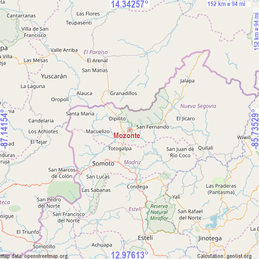
Mozonte GPS coordinates[2]
13° 39' 37.224" North, 86° 26' 18.276" West
| Map corner | latitude | longitude |
|---|---|---|
| Upper-left | 14.34257°, | -87.14154° |
| Center: | 13.66034°, | -86.43841° |
| Lower-right: | 12.97613°, | -85.73529° |
| Map W x H: | 151.9×151.9 km | = 94.4×94.4mi |
| max Lat: | 14.74189° ⇑6.6% North |
| Mozonte: | 13.66034° |
| min Lat: | ⇓93.4% South 10.94684° |
| min Long | Mozonte | max Long |
| -87.4516° | -86.43841° | -83.06145° |
| W 23.4%⇐ | ⇒76.6% E |
Elevation
Elevation of Mozonte is 697 m = 2287 ft, and this is 359.8 m = 1180 ft above average elevation for this country.
| Max E: |
1288 m = 4226 ft | 11.4% |
| Mozonte | 697 m 2287 ft | |
| Avg. | 337.2 m = 1106 ft | |
Min E: |
1 m = 3 ft | 88.6% |
See also: Nicaragua elevation on elevation.city.
Geographical zone
Mozonte is located in North Torrid zone (between Equator and Tropic of Cancer). Distance of this Northern Tropic circle is 1087 km =675.4 mi to North.| Distance of | km | miles | from Mozonte |
|---|---|---|---|
| North Pole | 8488.2 | 5274.3 | to North |
| Arctic Circle | 5882.3 | 3655.1 | to North |
| Tropic Cancer | 1087 | 675.4 | to North |
| Equator | 1518.9 | 943.8 | to South |


Nearby cities:
15 places around Mozonte: (largest is in red/bold)
• Ciudad Antigua
14.2 km =8.8 mi,  98°
98°
• Condega
33.1 km =20.6 mi,  172°
172°
• Dipilto
10 km =6.2 mi,  312°
312°
• El Jícaro
33.1 km =20.6 mi,  77°
77°
• Macuelizo
18.9 km =11.7 mi,  267°
267°
• Ocotal
5.1 km =3.2 mi,  231°
231°
• Palacagüina
23 km =14.3 mi, 171°
• Pueblo Nuevo
31.5 km =19.6 mi,  188°
188°
• San Fernando
13.5 km =8.4 mi, 81°
• San Juan de Río Coco
32.2 km =20 mi,  113°
113°
• Santa María
30.8 km =19.1 mi,  288°
288°
• Somoto
25.3 km =15.7 mi,  217°
217°
• Telpaneca
21.7 km =13.5 mi,  131°
131°
• Totogalpa
12.3 km =7.6 mi,  208°
208°
• Yalagüina
20.5 km =12.7 mi,  196°
196°
Sources, notices
• [Note1] Compared only with cities in Nicaragua existing in our database
• [Src1] Map data: © OpenStreetMap contributors (CC-BY-SA)
• [Src2] Other city data from geonames.org with taken over terms of usage.
• [Src3] Geographical zone / Annual Mean Temperature by Robert A. Rohde @ Wikipedia
