Ticuantepe geodata
Ticuantepe (Managua) is a seat of a second-order administrative division; located in Nicaragua in America/Managua (GMT-6) time zone. With population of 13,209 people, there are 40 cities with bigger population in this country. Compared to other cities in Nicaragua, 71.9% of cities are located further ↑North; 63.5% of cities are located further →East and 50.9% of cities have lower elevation than Ticuantepe. Note1


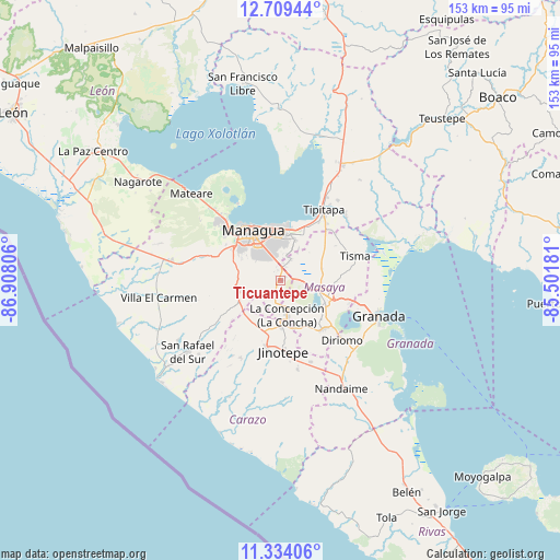
Ticuantepe GPS coordinates[2]
12° 1' 21.468" North, 86° 12' 17.748" West
| Map corner | latitude | longitude |
|---|---|---|
| Upper-left | 12.70944°, | -86.90806° |
| Center: | 12.02263°, | -86.20493° |
| Lower-right: | 11.33406°, | -85.50181° |
| Map W x H: | 152.9×152.9 km | = 95×95mi |
| max Lat: | 14.74189° ⇑71.9% North |
| Ticuantepe: | 12.02263° |
| min Lat: | ⇓28.1% South 10.94684° |
| min Long | Ticuantepe | max Long |
| -87.4516° | -86.20493° | -83.06145° |
| W 36.5%⇐ | ⇒63.5% E |
Elevation
Elevation of Ticuantepe is 302 m = 991 ft, and this is 35.2 m = 115 ft below average elevation for this country.
| Max E: |
1288 m = 4226 ft | 49.1% |
| Avg. | 337.2 m = 1106 ft | |
| Ticuantepe | 302 m = 991 ft | |
Min E: |
1 m = 3 ft | 50.9% |
See also: Nicaragua elevation on elevation.city.
Geographical zone
Ticuantepe is located in North Torrid zone (between Equator and Tropic of Cancer). Distance of this Northern Tropic circle is 1269.1 km =788.6 mi to North.| Distance of | km | miles | from Ticuantepe |
|---|---|---|---|
| North Pole | 8670.3 | 5387.5 | to North |
| Arctic Circle | 6064.4 | 3768.2 | to North |
| Tropic Cancer | 1269.1 | 788.6 | to North |
| Equator | 1336.8 | 830.6 | to South |


Nearby cities:
15 places around Ticuantepe: (largest is in red/bold)
• Catarina
18.8 km =11.7 mi,  130°
130°
• Diriamba
18.7 km =11.6 mi,  191°
191°
• Dolores
18.5 km =11.5 mi,  183°
183°
• El Crucero
11.9 km =7.4 mi,  252°
252°
• Jinotepe
19.2 km =11.9 mi, 178°
• La Concepción
9.7 km =6 mi,  170°
170°
• Managua
13.2 km =8.2 mi,  338°
338°
• Masatepe
13.7 km =8.5 mi,  151°
151°
• Masaya
13.2 km =8.2 mi,  113°
113°
• Nandasmo
14.3 km =8.9 mi,  140°
140°
• Nindirí
9.3 km =5.8 mi,  102°
102°
• Niquinohomo
17.7 km =11 mi, 137°
• San Juan de Oriente
19.3 km =12 mi, 132°
• San Marcos
12.6 km =7.8 mi, 179°
• Tisma
21.4 km =13.3 mi,  72°
72°
Sources, notices
• [Note1] Compared only with cities in Nicaragua existing in our database
• [Src1] Map data: © OpenStreetMap contributors (CC-BY-SA)
• [Src2] Other city data from geonames.org with taken over terms of usage.
• [Src3] Geographical zone / Annual Mean Temperature by Robert A. Rohde @ Wikipedia
