Santa Teresa geodata
Santa Teresa (Carazo) is a populated place; located in Nicaragua in America/Managua (GMT-6) time zone. With population of 5,789 people, there are 69 cities with bigger population in this country. Compared to other cities in Nicaragua, 88.6% of cities are located further ↑North; 64.1% of cities are located further →East and 56.3% of cities have higher elevation than Santa Teresa. Note1


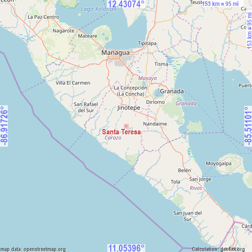
Santa Teresa GPS coordinates[2]
11° 44' 35.556" North, 86° 12' 50.868" West
| Map corner | latitude | longitude |
|---|---|---|
| Upper-left | 12.43074°, | -86.91726° |
| Center: | 11.74321°, | -86.21413° |
| Lower-right: | 11.05396°, | -85.51101° |
| Map W x H: | 153.1×153.1 km | = 95.1×95.1mi |
| max Lat: | 14.74189° ⇑88.6% North |
| Santa Teresa: | 11.74321° |
| min Lat: | ⇓11.4% South 10.94684° |
| min Long | Santa Teresa | max Long |
| -87.4516° | -86.21413° | -83.06145° |
| W 35.9%⇐ | ⇒64.1% E |
Elevation
Elevation of Santa Teresa is 184 m = 604 ft, and this is 153.2 m = 503 ft below average elevation for this country.
| Max E: |
1288 m = 4226 ft | 56.3% |
| Avg. | 337.2 m = 1106 ft | |
| Santa Teresa | 184 m = 604 ft | |
Min E: |
1 m = 3 ft | 43.7% |
See also: Nicaragua elevation on elevation.city.
Geographical zone
Santa Teresa is located in North Torrid zone (between Equator and Tropic of Cancer). Distance of this Northern Tropic circle is 1300.2 km =807.9 mi to North.| Distance of | km | miles | from Santa Teresa |
|---|---|---|---|
| North Pole | 8701.3 | 5406.7 | to North |
| Arctic Circle | 6095.5 | 3787.6 | to North |
| Tropic Cancer | 1300.2 | 807.9 | to North |
| Equator | 1305.7 | 811.3 | to South |


Nearby cities:
15 places around Santa Teresa: (largest is in red/bold)
• Diriamba
13.1 km =8.1 mi,  347°
347°
• Diriomo
23 km =14.3 mi,  50°
50°
• Dolores
12.6 km =7.8 mi,  359°
359°
• El Rosario
11.3 km =7 mi,  28°
28°
• El Rosario
17.8 km =11.1 mi,  282°
282°
• Jinotepe
11.9 km =7.4 mi,  7°
7°
• La Concepción
21.7 km =13.5 mi, 7°
• La Conquista
2.5 km =1.6 mi,  113°
113°
• La Paz de Carazo
12.9 km =8 mi, 46°
• Masatepe
20.5 km =12.7 mi,  21°
21°
• Nandaime
17.6 km =10.9 mi,  85°
85°
• Nandasmo
22.5 km =14 mi, 26°
• Niquinohomo
22.2 km =13.8 mi,  35°
35°
• San Marcos
18.5 km =11.5 mi,  3°
3°
• Santa Teresa
8.7 km =5.4 mi, 39°
Sources, notices
• [Note1] Compared only with cities in Nicaragua existing in our database
• [Src1] Map data: © OpenStreetMap contributors (CC-BY-SA)
• [Src2] Other city data from geonames.org with taken over terms of usage.
• [Src3] Geographical zone / Annual Mean Temperature by Robert A. Rohde @ Wikipedia
