Estelí geodata
Estelí is a seat of a first-order administrative division; located in Nicaragua in America/Managua (GMT-6) time zone. With population of 96,422 people, there are 5 cities with bigger population in this country. Compared to other cities in Nicaragua, 69.5% of cities are located further ↓South; 71.9% of cities are located further →East and 93.4% of cities have lower elevation than Estelí. Note1


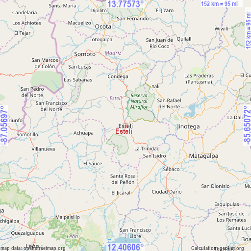
Estelí GPS coordinates[2]
13° 5' 30.66" North, 86° 21' 13.824" West
| Map corner | latitude | longitude |
|---|---|---|
| Upper-left | 13.77573°, | -87.05697° |
| Center: | 13.09185°, | -86.35384° |
| Lower-right: | 12.40606°, | -85.65072° |
| Map W x H: | 152.3×152.3 km | = 94.6×94.6mi |
| max Lat: | 14.74189° ⇑30.5% North |
| Estelí: | 13.09185° |
| min Lat: | ⇓69.5% South 10.94684° |
| min Long | Estelí | max Long |
| -87.4516° | -86.35384° | -83.06145° |
| W 28.1%⇐ | ⇒71.9% E |
Elevation
Elevation of Estelí is 840 m = 2756 ft, and this is 502.8 m = 1650 ft above average elevation for this country.
| Max E: |
1288 m = 4226 ft | 6.6% |
| Estelí | 840 m 2756 ft | |
| Avg. | 337.2 m = 1106 ft | |
Min E: |
1 m = 3 ft | 93.4% |
See also: Estelí elevation on elevation.city.
Geographical zone
Estelí is located in North Torrid zone (between Equator and Tropic of Cancer). Distance of this Northern Tropic circle is 1150.2 km =714.7 mi to North.| Distance of | km | miles | from Estelí |
|---|---|---|---|
| North Pole | 8551.4 | 5313.6 | to North |
| Arctic Circle | 5945.5 | 3694.4 | to North |
| Tropic Cancer | 1150.2 | 714.7 | to North |
| Equator | 1455.7 | 904.5 | to South |


Nearby cities:
15 places around Estelí: (largest is in red/bold)
• Achuapa
25.9 km =16.1 mi,  260°
260°
• Condega
30.8 km =19.1 mi,  350°
350°
• El Sauce
30.4 km =18.9 mi,  221°
221°
• Jinotega
38.1 km =23.7 mi,  90°
90°
• LLano de La Cruz
37.6 km =23.4 mi,  84°
84°
• La Concordia
23.3 km =14.5 mi,  60°
60°
• La Trinidad
18.8 km =11.7 mi,  136°
136°
• Pueblo Nuevo
34.8 km =21.6 mi,  336°
336°
• San Isidro
24.9 km =15.5 mi, 136°
• San Juan de Limay
29.5 km =18.3 mi,  288°
288°
• San Nicolás
17.7 km =11 mi,  177°
177°
• San Rafael del Norte
29.5 km =18.3 mi, 62°
• San Sebastián de Yalí
29.9 km =18.6 mi,  37°
37°
• Santa Rosa del Peñón
32.4 km =20.1 mi, 183°
• Sébaco
38.5 km =23.9 mi,  133°
133°
Sources, notices
• [Note1] Compared only with cities in Nicaragua existing in our database
• [Src1] Map data: © OpenStreetMap contributors (CC-BY-SA)
• [Src2] Other city data from geonames.org with taken over terms of usage.
• [Src3] Geographical zone / Annual Mean Temperature by Robert A. Rohde @ Wikipedia
