Zuidhoven geodata
Zuidhoven (South Holland) is a section of populated place; located in Netherlands in Europe/Amsterdam (GMT+2) time zone. With population of 970 people, there are 1423 cities with bigger population in this country. Compared to other cities in Netherlands, 64.9% of cities are located further ↑North; 83.9% of cities are located further →East and 83.9% of cities have higher elevation than Zuidhoven. Note1


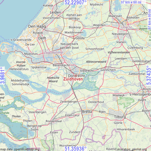
Zuidhoven GPS coordinates[2]
51° 47' 46.716" North, 4° 40' 16.392" East
| Map corner | latitude | longitude |
|---|---|---|
| Upper-left | 52.22907°, | 3.9681° |
| Center: | 51.79631°, | 4.67122° |
| Lower-right: | 51.35936°, | 5.37435° |
| Map W x H: | 96.7×96.7 km | = 60.1×60.1mi |
| max Lat: | 53.48025° ⇑64.9% North |
| Zuidhoven: | 51.79631° |
| min Lat: | ⇓35.1% South 50.76917° |
| min Long | Zuidhoven | max Long |
| 3.38611° | 4.67122° | 7.16528° |
| W 16.1%⇐ | ⇒83.9% E |
Elevation
Elevation of Zuidhoven is 1 m = 3 ft, and this is 14 m = 46 ft below average elevation for this country.
| Max E: |
203 m = 666 ft | 83.9% |
| Avg. | 15 m = 49 ft | |
| Zuidhoven | 1 m = 3 ft | |
Min E: |
-6 m = -20 ft | 16.1% |
See also: Netherlands elevation on elevation.city.
Geographical zone
Zuidhoven is located in North temperate zone (between Tropic of Cancer and the Arctic Circle). Distance of this North polar circle is 1642 km =1020.3 mi to North.| Distance of | km | miles | from Zuidhoven |
|---|---|---|---|
| North Pole | 4247.9 | 2639.5 | to North |
| Arctic Circle | 1642 | 1020.3 | to North |
| Tropic Cancer | 3153.3 | 1959.4 | to South |
| Equator | 5759.2 | 3578.6 | to South |


Nearby cities:
15 places around Zuidhoven: (largest is in red/bold)
• Alblasserdam
7.8 km =4.8 mi,  354°
354°
• De Peulen
10.8 km =6.7 mi,  73°
73°
• Dordrecht
1.5 km =0.9 mi,  6°
6°
• Heerjansdam
8.6 km =5.3 mi,  300°
300°
• Hendrik-Ido-Ambacht
5.8 km =3.6 mi,  337°
337°
• Kinderdijk
10.3 km =6.4 mi, 344°
• Maasdam
8 km =5 mi,  264°
264°
• Nieuw-Lekkerland
10.4 km =6.5 mi, 5°
• Papendrecht
4.1 km =2.5 mi,  15°
15°
• Ridderkerk
9.7 km =6 mi,  330°
330°
• Rijsoord
8 km =5 mi,  319°
319°
• Sliedrecht
7.7 km =4.8 mi, 69°
• Strijen
10 km =6.2 mi,  235°
235°
• Wijngaarden
8.3 km =5.2 mi,  49°
49°
• Zwijndrecht
3.5 km =2.2 mi,  312°
312°
Sources, notices
• [Note1] Compared only with cities in Netherlands existing in our database
• [Src1] Map data: © OpenStreetMap contributors (CC-BY-SA)
• [Src2] Other city data from geonames.org with taken over terms of usage.
• [Src3] Geographical zone / Annual Mean Temperature by Robert A. Rohde @ Wikipedia
