Wijngaarden geodata
Wijngaarden (South Holland) is a populated place; located in Netherlands in Europe/Amsterdam (GMT+2) time zone. With population of 680 people, there are 1644 cities with bigger population in this country. Compared to other cities in Netherlands, 61.5% of cities are located further ↑North; 81.2% of cities are located further →East and 98.2% of cities have higher elevation than Wijngaarden. Note1


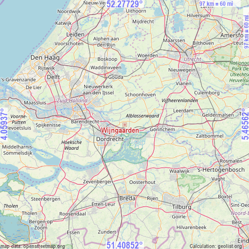
Wijngaarden GPS coordinates[2]
51° 50' 42" North, 4° 45' 45" East
| Map corner | latitude | longitude |
|---|---|---|
| Upper-left | 52.27729°, | 4.05937° |
| Center: | 51.845°, | 4.7625° |
| Lower-right: | 51.40852°, | 5.46562° |
| Map W x H: | 96.6×96.6 km | = 60×60mi |
| max Lat: | 53.48025° ⇑61.5% North |
| Wijngaarden: | 51.845° |
| min Lat: | ⇓38.5% South 50.76917° |
| min Long | Wijngaarden | max Long |
| 3.38611° | 4.7625° | 7.16528° |
| W 18.8%⇐ | ⇒81.2% E |
Elevation
Elevation of Wijngaarden is -2 m = -7 ft, and this is 17 m = 56 ft below average elevation for this country.
| Max E: |
203 m = 666 ft | 98.2% |
| Avg. | 15 m = 49 ft | |
| Wijngaarden | -2 m = -7 ft | |
Min E: |
-6 m = -20 ft | 1.8% |
See also: Netherlands elevation on elevation.city.
Geographical zone
Wijngaarden is located in North temperate zone (between Tropic of Cancer and the Arctic Circle). Distance of this North polar circle is 1636.6 km =1016.9 mi to North.| Distance of | km | miles | from Wijngaarden |
|---|---|---|---|
| North Pole | 4242.4 | 2636.1 | to North |
| Arctic Circle | 1636.6 | 1016.9 | to North |
| Tropic Cancer | 3158.7 | 1962.7 | to South |
| Equator | 5764.6 | 3582 | to South |


Nearby cities:
15 places around Wijngaarden: (largest is in red/bold)
• Alblasserdam
7.3 km =4.5 mi,  288°
288°
• Bergstoep
8.8 km =5.5 mi,  10°
10°
• Bleskensgraaf
3.4 km =2.1 mi,  25°
25°
• Boven-Hardinxveld
8.6 km =5.3 mi,  106°
106°
• De Peulen
4.7 km =2.9 mi,  120°
120°
• Dordrecht
7.2 km =4.5 mi,  237°
237°
• Giessenburg
8.8 km =5.5 mi,  85°
85°
• Giessendam
5.2 km =3.2 mi, 105°
• Hendrik-Ido-Ambacht
8.5 km =5.3 mi,  269°
269°
• Neder-Hardinxveld
6.6 km =4.1 mi, 105°
• Nieuw-Lekkerland
7.2 km =4.5 mi,  313°
313°
• Opperduit
6.9 km =4.3 mi,  330°
330°
• Papendrecht
5.4 km =3.4 mi,  253°
253°
• Sliedrecht
2.9 km =1.8 mi,  160°
160°
• Zuidhoven
8.3 km =5.2 mi,  229°
229°
Sources, notices
• [Note1] Compared only with cities in Netherlands existing in our database
• [Src1] Map data: © OpenStreetMap contributors (CC-BY-SA)
• [Src2] Other city data from geonames.org with taken over terms of usage.
• [Src3] Geographical zone / Annual Mean Temperature by Robert A. Rohde @ Wikipedia
