Alblasserdam geodata
Alblasserdam (South Holland) is a populated place; located in Netherlands in Europe/Amsterdam (GMT+2) time zone. With population of 18,348 people, there are 192 cities with bigger population in this country. Compared to other cities in Netherlands, 60.4% of cities are located further ↑North; 84.3% of cities are located further →East and 91.3% of cities have higher elevation than Alblasserdam. Note1


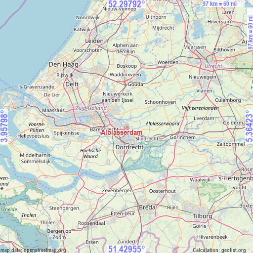
Alblasserdam GPS coordinates[2]
51° 51' 56.988" North, 4° 39' 39.996" East
| Map corner | latitude | longitude |
|---|---|---|
| Upper-left | 52.29792°, | 3.95798° |
| Center: | 51.86583°, | 4.66111° |
| Lower-right: | 51.42955°, | 5.36423° |
| Map W x H: | 96.6×96.6 km | = 60×60mi |
| max Lat: | 53.48025° ⇑60.4% North |
| Alblasserdam: | 51.86583° |
| min Lat: | ⇓39.6% South 50.76917° |
| min Long | Alblasserdam | max Long |
| 3.38611° | 4.66111° | 7.16528° |
| W 15.7%⇐ | ⇒84.3% E |
Elevation
Elevation of Alblasserdam is 0 m = 0 ft, and this is 15 m = 49 ft below average elevation for this country.
| Max E: |
203 m = 666 ft | 91.3% |
| Avg. | 15 m = 49 ft | |
| Alblasserdam | 0 m = 0 ft | |
Min E: |
-6 m = -20 ft | 8.7% |
See also: Netherlands elevation on elevation.city.
Geographical zone
Alblasserdam is located in North temperate zone (between Tropic of Cancer and the Arctic Circle). Distance of this North polar circle is 1634.2 km =1015.4 mi to North.| Distance of | km | miles | from Alblasserdam |
|---|---|---|---|
| North Pole | 4240.1 | 2634.7 | to North |
| Arctic Circle | 1634.2 | 1015.4 | to North |
| Tropic Cancer | 3161 | 1964.2 | to South |
| Equator | 5766.9 | 3583.4 | to South |


Nearby cities:
15 places around Alblasserdam: (largest is in red/bold)
• Bolnes
6.5 km =4 mi,  299°
299°
• Dordrecht
6.3 km =3.9 mi,  172°
172°
• Heerjansdam
7.5 km =4.7 mi,  243°
243°
• Hendrik-Ido-Ambacht
2.9 km =1.8 mi,  212°
212°
• Kinderdijk
3 km =1.9 mi,  317°
317°
• Krimpen aan den IJssel
6.9 km =4.3 mi, 324°
• Nieuw-Lekkerland
3.1 km =1.9 mi,  33°
33°
• Opperduit
5.1 km =3.2 mi,  43°
43°
• Papendrecht
4.2 km =2.6 mi,  154°
154°
• Ridderkerk
4.1 km =2.5 mi,  280°
280°
• Rijsoord
4.8 km =3 mi,  249°
249°
• Slikkerveer
4.4 km =2.7 mi, 299°
• Wijngaarden
7.3 km =4.5 mi,  108°
108°
• Zuidhoven
7.8 km =4.8 mi, 174°
• Zwijndrecht
5.7 km =3.5 mi,  199°
199°
Sources, notices
• [Note1] Compared only with cities in Netherlands existing in our database
• [Src1] Map data: © OpenStreetMap contributors (CC-BY-SA)
• [Src2] Other city data from geonames.org with taken over terms of usage.
• [Src3] Geographical zone / Annual Mean Temperature by Robert A. Rohde @ Wikipedia
