Hendrik-Ido-Ambacht geodata
Hendrik-Ido-Ambacht (South Holland) is a populated place; located in Netherlands in Europe/Amsterdam (GMT+2) time zone. With population of 21,027 people, there are 163 cities with bigger population in this country. Compared to other cities in Netherlands, 61.6% of cities are located further ↑North; 85.2% of cities are located further →East and 99.2% of cities have higher elevation than Hendrik-Ido-Ambacht. Note1


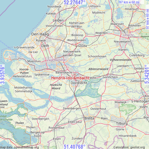
Hendrik-Ido-Ambacht GPS coordinates[2]
51° 50' 39.012" North, 4° 38' 20.004" East
| Map corner | latitude | longitude |
|---|---|---|
| Upper-left | 52.27647°, | 3.93576° |
| Center: | 51.84417°, | 4.63889° |
| Lower-right: | 51.40768°, | 5.34201° |
| Map W x H: | 96.6×96.6 km | = 60×60mi |
| max Lat: | 53.48025° ⇑61.6% North |
| Hendrik-Ido-Ambacht: | 51.84417° |
| min Lat: | ⇓38.4% South 50.76917° |
| min Long | Hendrik-Ido-Amb | max Long |
| 3.38611° | 4.63889° | 7.16528° |
| W 14.8%⇐ | ⇒85.2% E |
Elevation
Elevation of Hendrik-Ido-Ambacht is -3 m = -10 ft, and this is 18 m = 59 ft below average elevation for this country.
| Max E: |
203 m = 666 ft | 99.2% |
| Avg. | 15 m = 49 ft | |
| Hendrik-Ido-Ambacht | -3 m = -10 ft | |
Min E: |
-6 m = -20 ft | 0.8% |
See also: Netherlands elevation on elevation.city.
Geographical zone
Hendrik-Ido-Ambacht is located in North temperate zone (between Tropic of Cancer and the Arctic Circle). Distance of this North polar circle is 1636.6 km =1016.9 mi to North.| Distance of | km | miles | from Hendrik-Ido-Ambacht |
|---|---|---|---|
| North Pole | 4242.5 | 2636.2 | to North |
| Arctic Circle | 1636.6 | 1016.9 | to North |
| Tropic Cancer | 3158.6 | 1962.7 | to South |
| Equator | 5764.5 | 3581.9 | to South |


Nearby cities:
15 places around Hendrik-Ido-Ambacht: (largest is in red/bold)
• Alblasserdam
2.9 km =1.8 mi,  32°
32°
• Barendrecht
7.3 km =4.5 mi,  280°
280°
• Bolnes
7 km =4.3 mi,  324°
324°
• Dordrecht
4.5 km =2.8 mi,  147°
147°
• Groot IJsselmonde
7.5 km =4.7 mi,  304°
304°
• Heerjansdam
5.2 km =3.2 mi,  259°
259°
• Kinderdijk
4.7 km =2.9 mi,  354°
354°
• Nieuw-Lekkerland
6 km =3.7 mi, 33°
• Opperduit
7.9 km =4.9 mi,  39°
39°
• Papendrecht
3.6 km =2.2 mi,  112°
112°
• Ridderkerk
4 km =2.5 mi, 321°
• Rijsoord
3 km =1.9 mi, 284°
• Slikkerveer
5.1 km =3.2 mi,  332°
332°
• Zuidhoven
5.8 km =3.6 mi,  157°
157°
• Zwijndrecht
3 km =1.9 mi,  187°
187°
Sources, notices
• [Note1] Compared only with cities in Netherlands existing in our database
• [Src1] Map data: © OpenStreetMap contributors (CC-BY-SA)
• [Src2] Other city data from geonames.org with taken over terms of usage.
• [Src3] Geographical zone / Annual Mean Temperature by Robert A. Rohde @ Wikipedia
