Zeddam geodata
Zeddam (Gelderland) is a populated place; located in Netherlands in Europe/Amsterdam (GMT+2) time zone. With population of 2,305 people, there are 889 cities with bigger population in this country. Compared to other cities in Netherlands, 57.6% of cities are located further ↑North; 84.8% of cities are located further ←West and 78.8% of cities have lower elevation than Zeddam. Note1


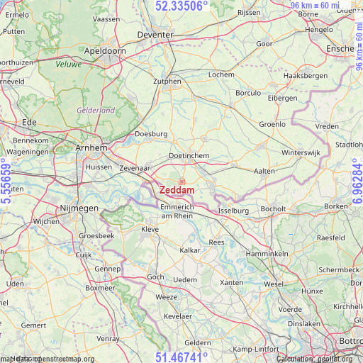
Zeddam GPS coordinates[2]
51° 54' 11.988" North, 6° 15' 34.992" East
| Map corner | latitude | longitude |
|---|---|---|
| Upper-left | 52.33506°, | 5.55659° |
| Center: | 51.90333°, | 6.25972° |
| Lower-right: | 51.46741°, | 6.96284° |
| Map W x H: | 96.5×96.5 km | = 60×60mi |
| max Lat: | 53.48025° ⇑57.6% North |
| Zeddam: | 51.90333° |
| min Lat: | ⇓42.4% South 50.76917° |
| min Long | Zeddam | max Long |
| 3.38611° | 6.25972° | 7.16528° |
| W 84.8%⇐ | ⇒15.2% E |
Elevation
Elevation of Zeddam is 20 m = 66 ft, and this is 5 m = 16 ft above average elevation for this country.
| Max E: |
203 m = 666 ft | 21.2% |
| Zeddam | 20 m 66 ft | |
| Avg. | 15 m = 49 ft | |
Min E: |
-6 m = -20 ft | 78.8% |
See also: Netherlands elevation on elevation.city.
Geographical zone
Zeddam is located in North temperate zone (between Tropic of Cancer and the Arctic Circle). Distance of this North polar circle is 1630.1 km =1012.9 mi to North.| Distance of | km | miles | from Zeddam |
|---|---|---|---|
| North Pole | 4236 | 2632.1 | to North |
| Arctic Circle | 1630.1 | 1012.9 | to North |
| Tropic Cancer | 3165.2 | 1966.8 | to South |
| Equator | 5771.1 | 3586 | to South |


Nearby cities:
15 places around Zeddam: (largest is in red/bold)
• 's-Heerenberg
3 km =1.9 mi,  181°
181°
• Babberich
10.2 km =6.3 mi,  272°
272°
• Beek gem Montferland
5 km =3.1 mi, 274°
• Braamt
2.3 km =1.4 mi,  9°
9°
• Doetinchem
7.1 km =4.4 mi,  16°
16°
• Etten
5.4 km =3.4 mi,  74°
74°
• Gendringen
8.7 km =5.4 mi,  112°
112°
• Kilder
4.3 km =2.7 mi,  333°
333°
• Lobith
10.7 km =6.6 mi,  244°
244°
• Loil
9.8 km =6.1 mi,  304°
304°
• Nieuw-Dijk
7.9 km =4.9 mi, 295°
• Silvolde
8.8 km =5.5 mi,  85°
85°
• Spijk
9.4 km =5.8 mi,  230°
230°
• Stokkum
3.9 km =2.4 mi,  222°
222°
• Terborg
6.7 km =4.2 mi, 74°
Sources, notices
• [Note1] Compared only with cities in Netherlands existing in our database
• [Src1] Map data: © OpenStreetMap contributors (CC-BY-SA)
• [Src2] Other city data from geonames.org with taken over terms of usage.
• [Src3] Geographical zone / Annual Mean Temperature by Robert A. Rohde @ Wikipedia
