Silvolde geodata
Silvolde (Gelderland) is a populated place; located in Netherlands in Europe/Amsterdam (GMT+2) time zone. With population of 4,850 people, there are 501 cities with bigger population in this country. Compared to other cities in Netherlands, 57.1% of cities are located further ↑North; 87% of cities are located further ←West and 72.5% of cities have lower elevation than Silvolde. Note1


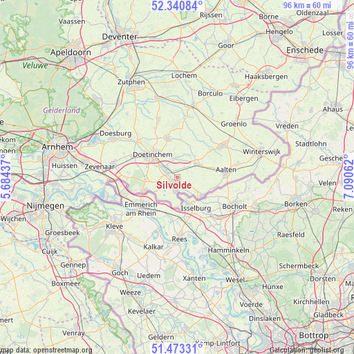
Silvolde GPS coordinates[2]
51° 54' 33.012" North, 6° 23' 15" East
| Map corner | latitude | longitude |
|---|---|---|
| Upper-left | 52.34084°, | 5.68437° |
| Center: | 51.90917°, | 6.3875° |
| Lower-right: | 51.47331°, | 7.09062° |
| Map W x H: | 96.5×96.5 km | = 60×60mi |
| max Lat: | 53.48025° ⇑57.1% North |
| Silvolde: | 51.90917° |
| min Lat: | ⇓42.9% South 50.76917° |
| min Long | Silvolde | max Long |
| 3.38611° | 6.3875° | 7.16528° |
| W 87%⇐ | ⇒13% E |
Elevation
Elevation of Silvolde is 16 m = 52 ft, and this is 1 m = 3 ft above average elevation for this country.
| Max E: |
203 m = 666 ft | 27.5% |
| Silvolde | 16 m 52 ft | |
| Avg. | 15 m = 49 ft | |
Min E: |
-6 m = -20 ft | 72.5% |
See also: Netherlands elevation on elevation.city.
Geographical zone
Silvolde is located in North temperate zone (between Tropic of Cancer and the Arctic Circle). Distance of this North polar circle is 1629.4 km =1012.5 mi to North.| Distance of | km | miles | from Silvolde |
|---|---|---|---|
| North Pole | 4235.3 | 2631.7 | to North |
| Arctic Circle | 1629.4 | 1012.5 | to North |
| Tropic Cancer | 3165.8 | 1967.1 | to South |
| Equator | 5771.8 | 3586.4 | to South |


Nearby cities:
15 places around Silvolde: (largest is in red/bold)
• 's-Heerenberg
9.5 km =5.9 mi,  247°
247°
• Aalten
13.4 km =8.3 mi,  82°
82°
• Braamt
8.5 km =5.3 mi,  280°
280°
• Doetinchem
9.2 km =5.7 mi,  312°
312°
• Etten
3.6 km =2.2 mi, 283°
• Gendringen
4.1 km =2.5 mi,  190°
190°
• Halle
9.3 km =5.8 mi,  17°
17°
• Kilder
11.1 km =6.9 mi,  286°
286°
• Megchelen
7.9 km =4.9 mi,  177°
177°
• Stokkum
12 km =7.5 mi, 252°
• Terborg
2.6 km =1.6 mi,  297°
297°
• Varsseveld
6.2 km =3.9 mi,  51°
51°
• Wisch
2.8 km =1.7 mi, 46°
• Zeddam
8.8 km =5.5 mi,  265°
265°
• Zelhem
11.2 km =7 mi,  346°
346°
Sources, notices
• [Note1] Compared only with cities in Netherlands existing in our database
• [Src1] Map data: © OpenStreetMap contributors (CC-BY-SA)
• [Src2] Other city data from geonames.org with taken over terms of usage.
• [Src3] Geographical zone / Annual Mean Temperature by Robert A. Rohde @ Wikipedia
