Kilder geodata
Kilder (Gelderland) is a populated place; located in Netherlands in Europe/Amsterdam (GMT+2) time zone. With population of 980 people, there are 1415 cities with bigger population in this country. Compared to other cities in Netherlands, 54.9% of cities are located further ↑North; 84.1% of cities are located further ←West and 72.5% of cities have lower elevation than Kilder. Note1


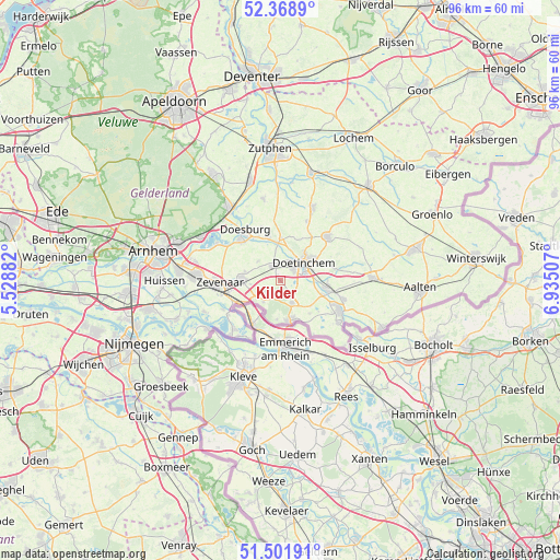
Kilder GPS coordinates[2]
51° 56' 15" North, 6° 13' 54.984" East
| Map corner | latitude | longitude |
|---|---|---|
| Upper-left | 52.3689°, | 5.52882° |
| Center: | 51.9375°, | 6.23194° |
| Lower-right: | 51.50191°, | 6.93507° |
| Map W x H: | 96.4×96.4 km | = 59.9×59.9mi |
| max Lat: | 53.48025° ⇑54.9% North |
| Kilder: | 51.9375° |
| min Lat: | ⇓45.1% South 50.76917° |
| min Long | Kilder | max Long |
| 3.38611° | 6.23194° | 7.16528° |
| W 84.1%⇐ | ⇒15.9% E |
Elevation
Elevation of Kilder is 16 m = 52 ft, and this is 1 m = 3 ft above average elevation for this country.
| Max E: |
203 m = 666 ft | 27.5% |
| Kilder | 16 m 52 ft | |
| Avg. | 15 m = 49 ft | |
Min E: |
-6 m = -20 ft | 72.5% |
See also: Netherlands elevation on elevation.city.
Geographical zone
Kilder is located in North temperate zone (between Tropic of Cancer and the Arctic Circle). Distance of this North polar circle is 1626.3 km =1010.5 mi to North.| Distance of | km | miles | from Kilder |
|---|---|---|---|
| North Pole | 4232.2 | 2629.8 | to North |
| Arctic Circle | 1626.3 | 1010.5 | to North |
| Tropic Cancer | 3169 | 1969.1 | to South |
| Equator | 5774.9 | 3588.4 | to South |


Nearby cities:
15 places around Kilder: (largest is in red/bold)
• 's-Heerenberg
7 km =4.3 mi,  164°
164°
• Angerlo
9.3 km =5.8 mi,  314°
314°
• Babberich
8.9 km =5.5 mi,  248°
248°
• Beek gem Montferland
4.6 km =2.9 mi,  221°
221°
• Braamt
2.8 km =1.7 mi,  124°
124°
• Doesburg
10.5 km =6.5 mi,  322°
322°
• Doetinchem
5 km =3.1 mi,  51°
51°
• Drempt
8.7 km =5.4 mi,  333°
333°
• Etten
7.5 km =4.7 mi,  107°
107°
• Hummelo
7.4 km =4.6 mi,  0°
0°
• Loil
6.4 km =4 mi,  285°
285°
• Nieuw-Dijk
5.3 km =3.3 mi,  264°
264°
• Stokkum
6.7 km =4.2 mi,  186°
186°
• Terborg
8.6 km =5.3 mi,  103°
103°
• Zeddam
4.3 km =2.7 mi,  153°
153°
Sources, notices
• [Note1] Compared only with cities in Netherlands existing in our database
• [Src1] Map data: © OpenStreetMap contributors (CC-BY-SA)
• [Src2] Other city data from geonames.org with taken over terms of usage.
• [Src3] Geographical zone / Annual Mean Temperature by Robert A. Rohde @ Wikipedia
