Vlagtwedde geodata
Vlagtwedde (Groningen) is a populated place; located in Netherlands in Europe/Amsterdam (GMT+2) time zone. With population of 1,955 people, there are 976 cities with bigger population in this country. Compared to other cities in Netherlands, 86.3% of cities are located further ↓South; 99.8% of cities are located further ←West and 65.8% of cities have higher elevation than Vlagtwedde. Note1


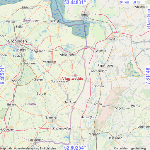
Vlagtwedde GPS coordinates[2]
53° 1' 39" North, 7° 6' 29.988" East
| Map corner | latitude | longitude |
|---|---|---|
| Upper-left | 53.44831°, | 6.40521° |
| Center: | 53.0275°, | 7.10833° |
| Lower-right: | 52.60254°, | 7.81146° |
| Map W x H: | 94×94 km | = 58.4×58.4mi |
| max Lat: | 53.48025° ⇑13.7% North |
| Vlagtwedde: | 53.0275° |
| min Lat: | ⇓86.3% South 50.76917° |
| min Long | Vlagtwedde | max Long |
| 3.38611° | 7.10833° | 7.16528° |
| W 99.8%⇐ | ⇒0.2% E |
Elevation
Elevation of Vlagtwedde is 3 m = 10 ft, and this is 12 m = 39 ft below average elevation for this country.
| Max E: |
203 m = 666 ft | 65.8% |
| Avg. | 15 m = 49 ft | |
| Vlagtwedde | 3 m = 10 ft | |
Min E: |
-6 m = -20 ft | 34.2% |
See also: Netherlands elevation on elevation.city.
Geographical zone
Vlagtwedde is located in North temperate zone (between Tropic of Cancer and the Arctic Circle). Distance of this North polar circle is 1505.1 km =935.2 mi to North.| Distance of | km | miles | from Vlagtwedde |
|---|---|---|---|
| North Pole | 4111 | 2554.5 | to North |
| Arctic Circle | 1505.1 | 935.2 | to North |
| Tropic Cancer | 3290.2 | 2044.4 | to South |
| Equator | 5896.1 | 3663.7 | to South |


Nearby cities:
15 places around Vlagtwedde: (largest is in red/bold)
• Alteveer
8 km =5 mi,  288°
288°
• Bellingwolde
10.5 km =6.5 mi,  21°
21°
• Blijham
9.3 km =5.8 mi,  346°
346°
• Ceresdorp
11.3 km =7 mi,  232°
232°
• Mussel
9.3 km =5.8 mi,  209°
209°
• Nieuw-Buinen
12.8 km =8 mi,  235°
235°
• Nieuwe Pekela
11.2 km =7 mi,  301°
301°
• Onstwedde
4.6 km =2.9 mi,  280°
280°
• Oude Pekela
10.8 km =6.7 mi,  322°
322°
• Sellingen
9.5 km =5.9 mi,  162°
162°
• Stadskanaal
11.4 km =7.1 mi,  248°
248°
• Ter Apelkanaal
14.5 km =9 mi,  196°
196°
• Veelerveen
3.4 km =2.1 mi, 22°
• Wedde
5 km =3.1 mi,  337°
337°
• Winschoten
13.9 km =8.6 mi, 339°
Sources, notices
• [Note1] Compared only with cities in Netherlands existing in our database
• [Src1] Map data: © OpenStreetMap contributors (CC-BY-SA)
• [Src2] Other city data from geonames.org with taken over terms of usage.
• [Src3] Geographical zone / Annual Mean Temperature by Robert A. Rohde @ Wikipedia
