Mussel geodata
Mussel (Groningen) is a populated place; located in Netherlands in Europe/Amsterdam (GMT+2) time zone. With population of 985 people, there are 1414 cities with bigger population in this country. Compared to other cities in Netherlands, 84.2% of cities are located further ↓South; 99.4% of cities are located further ←West and 55.1% of cities have lower elevation than Mussel. Note1


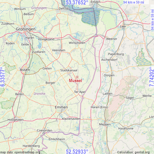
Mussel GPS coordinates[2]
52° 57' 18" North, 7° 2' 20.004" East
| Map corner | latitude | longitude |
|---|---|---|
| Upper-left | 53.37652°, | 6.33577° |
| Center: | 52.955°, | 7.03889° |
| Lower-right: | 52.52933°, | 7.74202° |
| Map W x H: | 94.2×94.2 km | = 58.5×58.5mi |
| max Lat: | 53.48025° ⇑15.8% North |
| Mussel: | 52.955° |
| min Lat: | ⇓84.2% South 50.76917° |
| min Long | Mussel | max Long |
| 3.38611° | 7.03889° | 7.16528° |
| W 99.4%⇐ | ⇒0.59999999999999% E |
Elevation
Elevation of Mussel is 8 m = 26 ft, and this is 7 m = 23 ft below average elevation for this country.
| Max E: |
203 m = 666 ft | 44.9% |
| Avg. | 15 m = 49 ft | |
| Mussel | 8 m = 26 ft | |
Min E: |
-6 m = -20 ft | 55.1% |
See also: Netherlands elevation on elevation.city.
Geographical zone
Mussel is located in North temperate zone (between Tropic of Cancer and the Arctic Circle). Distance of this North polar circle is 1513.1 km =940.2 mi to North.| Distance of | km | miles | from Mussel |
|---|---|---|---|
| North Pole | 4119 | 2559.4 | to North |
| Arctic Circle | 1513.1 | 940.2 | to North |
| Tropic Cancer | 3282.1 | 2039.4 | to South |
| Equator | 5888 | 3658.6 | to South |


Nearby cities:
15 places around Mussel: (largest is in red/bold)
• Alteveer
11.1 km =6.9 mi,  344°
344°
• Ceresdorp
4.6 km =2.9 mi,  285°
285°
• Drouwenermond
9.3 km =5.8 mi, 286°
• Gasselternijveenschemond
10.4 km =6.5 mi,  295°
295°
• Nieuw-Buinen
6 km =3.7 mi,  277°
277°
• Onstwedde
8.9 km =5.5 mi,  0°
0°
• Sellingen
7.6 km =4.7 mi,  97°
97°
• Stadskanaal
7.1 km =4.4 mi, 302°
• Ter Apel
8.8 km =5.5 mi,  170°
170°
• Ter Apelkanaal
5.9 km =3.7 mi, 173°
• Tweede Exloërmond
8.7 km =5.4 mi,  234°
234°
• Valthermond
9.6 km =6 mi,  212°
212°
• Veelerveen
12.7 km =7.9 mi,  27°
27°
• Vlagtwedde
9.3 km =5.8 mi, 29°
• Wedde
13 km =8.1 mi,  11°
11°
Sources, notices
• [Note1] Compared only with cities in Netherlands existing in our database
• [Src1] Map data: © OpenStreetMap contributors (CC-BY-SA)
• [Src2] Other city data from geonames.org with taken over terms of usage.
• [Src3] Geographical zone / Annual Mean Temperature by Robert A. Rohde @ Wikipedia
