Sellingen geodata
Sellingen (Groningen) is a seat of a second-order administrative division; located in Netherlands in Europe/Amsterdam (GMT+2) time zone. With population of 1,060 people, there are 1355 cities with bigger population in this country. Compared to other cities in Netherlands, 83.9% of cities are located further ↓South; 99.9% of cities are located further ←West and 52.4% of cities have lower elevation than Sellingen. Note1


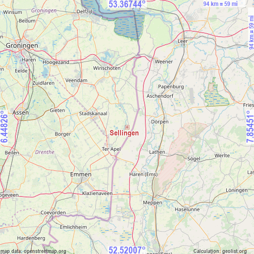
Sellingen GPS coordinates[2]
52° 56' 44.988" North, 7° 9' 5.004" East
| Map corner | latitude | longitude |
|---|---|---|
| Upper-left | 53.36744°, | 6.44826° |
| Center: | 52.94583°, | 7.15139° |
| Lower-right: | 52.52007°, | 7.85451° |
| Map W x H: | 94.2×94.2 km | = 58.5×58.5mi |
| max Lat: | 53.48025° ⇑16.1% North |
| Sellingen: | 52.94583° |
| min Lat: | ⇓83.9% South 50.76917° |
| min Long | Sellingen | max Long |
| 3.38611° | 7.15139° | 7.16528° |
| W 99.9%⇐ | ⇒0.099999999999994% E |
Elevation
Elevation of Sellingen is 7 m = 23 ft, and this is 8 m = 26 ft below average elevation for this country.
| Max E: |
203 m = 666 ft | 47.6% |
| Avg. | 15 m = 49 ft | |
| Sellingen | 7 m = 23 ft | |
Min E: |
-6 m = -20 ft | 52.4% |
See also: Netherlands elevation on elevation.city.
Geographical zone
Sellingen is located in North temperate zone (between Tropic of Cancer and the Arctic Circle). Distance of this North polar circle is 1514.1 km =940.8 mi to North.| Distance of | km | miles | from Sellingen |
|---|---|---|---|
| North Pole | 4120 | 2560 | to North |
| Arctic Circle | 1514.1 | 940.8 | to North |
| Tropic Cancer | 3281.1 | 2038.8 | to South |
| Equator | 5887 | 3658 | to South |


Nearby cities:
15 places around Sellingen: (largest is in red/bold)
• Alteveer
15.7 km =9.8 mi,  318°
318°
• Ceresdorp
12.1 km =7.5 mi,  280°
280°
• Drouwenermond
16.9 km =10.5 mi, 282°
• Emmer-Compascuum
16.5 km =10.3 mi,  205°
205°
• Mussel
7.6 km =4.7 mi, 277°
• Nieuw-Buinen
13.6 km =8.5 mi, 277°
• Onstwedde
12.4 km =7.7 mi, 323°
• Stadskanaal
14.3 km =8.9 mi,  289°
289°
• Ter Apel
9.8 km =6.1 mi,  218°
218°
• Ter Apelkanaal
8.4 km =5.2 mi,  235°
235°
• Tweede Exloërmond
15.2 km =9.4 mi,  254°
254°
• Valthermond
14.5 km =9 mi, 240°
• Veelerveen
12.3 km =7.6 mi,  352°
352°
• Vlagtwedde
9.5 km =5.9 mi,  342°
342°
• Wedde
14.5 km =9 mi, 340°
Sources, notices
• [Note1] Compared only with cities in Netherlands existing in our database
• [Src1] Map data: © OpenStreetMap contributors (CC-BY-SA)
• [Src2] Other city data from geonames.org with taken over terms of usage.
• [Src3] Geographical zone / Annual Mean Temperature by Robert A. Rohde @ Wikipedia
