Stadskanaal geodata
Stadskanaal (Groningen) is a populated place; located in Netherlands in Europe/Amsterdam (GMT+2) time zone. With population of 20,000 people, there are 174 cities with bigger population in this country. Compared to other cities in Netherlands, 85.2% of cities are located further ↓South; 98.2% of cities are located further ←West and 54.1% of cities have higher elevation than Stadskanaal. Note1


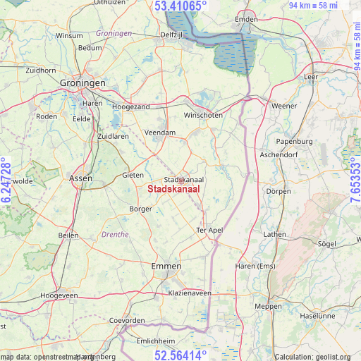
Stadskanaal GPS coordinates[2]
52° 59' 22.092" North, 6° 57' 1.44" East
| Map corner | latitude | longitude |
|---|---|---|
| Upper-left | 53.41065°, | 6.24728° |
| Center: | 52.98947°, | 6.9504° |
| Lower-right: | 52.56414°, | 7.65353° |
| Map W x H: | 94.1×94.1 km | = 58.5×58.5mi |
| max Lat: | 53.48025° ⇑14.8% North |
| Stadskanaal: | 52.98947° |
| min Lat: | ⇓85.2% South 50.76917° |
| min Long | Stadskanaal | max Long |
| 3.38611° | 6.9504° | 7.16528° |
| W 98.2%⇐ | ⇒1.8% E |
Elevation
Elevation of Stadskanaal is 5 m = 16 ft, and this is 10 m = 33 ft below average elevation for this country.
| Max E: |
203 m = 666 ft | 54.1% |
| Avg. | 15 m = 49 ft | |
| Stadskanaal | 5 m = 16 ft | |
Min E: |
-6 m = -20 ft | 45.9% |
See also: Netherlands elevation on elevation.city.
Geographical zone
Stadskanaal is located in North temperate zone (between Tropic of Cancer and the Arctic Circle). Distance of this North polar circle is 1509.3 km =937.8 mi to North.| Distance of | km | miles | from Stadskanaal |
|---|---|---|---|
| North Pole | 4115.2 | 2557.1 | to North |
| Arctic Circle | 1509.3 | 937.8 | to North |
| Tropic Cancer | 3286 | 2041.8 | to South |
| Equator | 5891.9 | 3661.1 | to South |


Nearby cities:
15 places around Stadskanaal: (largest is in red/bold)
• Alteveer
7.4 km =4.6 mi,  23°
23°
• Buinen
10.1 km =6.3 mi,  229°
229°
• Ceresdorp
3 km =1.9 mi,  149°
149°
• Drouwenermond
3.2 km =2 mi,  247°
247°
• Gasselte
10.6 km =6.6 mi,  259°
259°
• Gasselternijveen
6.5 km =4 mi,  268°
268°
• Gasselternijveenschemond
3.5 km =2.2 mi,  279°
279°
• Gieterveen
8.7 km =5.4 mi,  299°
299°
• Mussel
7.1 km =4.4 mi,  122°
122°
• Nieuw-Buinen
3 km =1.9 mi,  180°
180°
• Nieuwe Pekela
10 km =6.2 mi,  5°
5°
• Ommelanderwijk
11.5 km =7.1 mi,  344°
344°
• Onstwedde
7.9 km =4.9 mi,  49°
49°
• Tweede Exloërmond
9 km =5.6 mi,  187°
187°
• Vlagtwedde
11.4 km =7.1 mi,  68°
68°
Sources, notices
• [Note1] Compared only with cities in Netherlands existing in our database
• [Src1] Map data: © OpenStreetMap contributors (CC-BY-SA)
• [Src2] Other city data from geonames.org with taken over terms of usage.
• [Src3] Geographical zone / Annual Mean Temperature by Robert A. Rohde @ Wikipedia
