Nieuw-Buinen geodata
Nieuw-Buinen (Drenthe) is a populated place; located in Netherlands in Europe/Amsterdam (GMT+2) time zone. With population of 4,705 people, there are 514 cities with bigger population in this country. Compared to other cities in Netherlands, 84.5% of cities are located further ↓South; 98.1% of cities are located further ←West and 50.6% of cities have higher elevation than Nieuw-Buinen. Note1


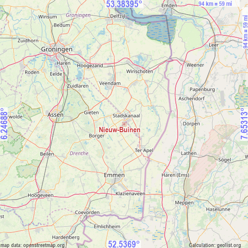
Nieuw-Buinen GPS coordinates[2]
52° 57' 45" North, 6° 57' 0" East
| Map corner | latitude | longitude |
|---|---|---|
| Upper-left | 53.38395°, | 6.24688° |
| Center: | 52.9625°, | 6.95° |
| Lower-right: | 52.5369°, | 7.65313° |
| Map W x H: | 94.2×94.2 km | = 58.5×58.5mi |
| max Lat: | 53.48025° ⇑15.5% North |
| Nieuw-Buinen: | 52.9625° |
| min Lat: | ⇓84.5% South 50.76917° |
| min Long | Nieuw-Buinen | max Long |
| 3.38611° | 6.95° | 7.16528° |
| W 98.1%⇐ | ⇒1.9% E |
Elevation
Elevation of Nieuw-Buinen is 6 m = 20 ft, and this is 9 m = 30 ft below average elevation for this country.
| Max E: |
203 m = 666 ft | 50.6% |
| Avg. | 15 m = 49 ft | |
| Nieuw-Buinen | 6 m = 20 ft | |
Min E: |
-6 m = -20 ft | 49.4% |
See also: Netherlands elevation on elevation.city.
Geographical zone
Nieuw-Buinen is located in North temperate zone (between Tropic of Cancer and the Arctic Circle). Distance of this North polar circle is 1512.3 km =939.7 mi to North.| Distance of | km | miles | from Nieuw-Buinen |
|---|---|---|---|
| North Pole | 4118.2 | 2558.9 | to North |
| Arctic Circle | 1512.3 | 939.7 | to North |
| Tropic Cancer | 3283 | 2040 | to South |
| Equator | 5888.9 | 3659.2 | to South |


Nearby cities:
15 places around Nieuw-Buinen: (largest is in red/bold)
• Alteveer
10.3 km =6.4 mi,  16°
16°
• Buinen
8.4 km =5.2 mi,  245°
245°
• Ceresdorp
1.6 km =1 mi,  75°
75°
• Drouwenermond
3.5 km =2.2 mi,  300°
300°
• Exloo
10.6 km =6.6 mi,  212°
212°
• Gasselte
10.5 km =6.5 mi,  275°
275°
• Gasselternijveen
7.1 km =4.4 mi,  293°
293°
• Gasselternijveenschemond
5 km =3.1 mi,  315°
315°
• Gieterveen
10.4 km =6.5 mi,  313°
313°
• Mussel
6 km =3.7 mi,  97°
97°
• Onstwedde
10.1 km =6.3 mi,  36°
36°
• Stadskanaal
3 km =1.9 mi,  0°
0°
• Ter Apelkanaal
9.4 km =5.8 mi,  135°
135°
• Tweede Exloërmond
6 km =3.7 mi,  190°
190°
• Valthermond
9 km =5.6 mi,  174°
174°
Sources, notices
• [Note1] Compared only with cities in Netherlands existing in our database
• [Src1] Map data: © OpenStreetMap contributors (CC-BY-SA)
• [Src2] Other city data from geonames.org with taken over terms of usage.
• [Src3] Geographical zone / Annual Mean Temperature by Robert A. Rohde @ Wikipedia
