Varsseveld geodata
Varsseveld (Gelderland) is a populated place; located in Netherlands in Europe/Amsterdam (GMT+2) time zone. With population of 5,450 people, there are 445 cities with bigger population in this country. Compared to other cities in Netherlands, 54.6% of cities are located further ↑North; 88.1% of cities are located further ←West and 77.1% of cities have lower elevation than Varsseveld. Note1


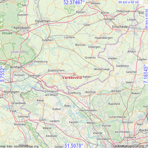
Varsseveld GPS coordinates[2]
51° 56' 35.988" North, 6° 27' 29.988" East
| Map corner | latitude | longitude |
|---|---|---|
| Upper-left | 52.37467°, | 5.7552° |
| Center: | 51.94333°, | 6.45833° |
| Lower-right: | 51.5078°, | 7.16145° |
| Map W x H: | 96.4×96.4 km | = 59.9×59.9mi |
| max Lat: | 53.48025° ⇑54.6% North |
| Varsseveld: | 51.94333° |
| min Lat: | ⇓45.4% South 50.76917° |
| min Long | Varsseveld | max Long |
| 3.38611° | 6.45833° | 7.16528° |
| W 88.1%⇐ | ⇒11.9% E |
Elevation
Elevation of Varsseveld is 19 m = 62 ft, and this is 4 m = 13 ft above average elevation for this country.
| Max E: |
203 m = 666 ft | 22.9% |
| Varsseveld | 19 m 62 ft | |
| Avg. | 15 m = 49 ft | |
Min E: |
-6 m = -20 ft | 77.1% |
See also: Netherlands elevation on elevation.city.
Geographical zone
Varsseveld is located in North temperate zone (between Tropic of Cancer and the Arctic Circle). Distance of this North polar circle is 1625.6 km =1010.1 mi to North.| Distance of | km | miles | from Varsseveld |
|---|---|---|---|
| North Pole | 4231.5 | 2629.3 | to North |
| Arctic Circle | 1625.6 | 1010.1 | to North |
| Tropic Cancer | 3169.6 | 1969.5 | to South |
| Equator | 5775.6 | 3588.8 | to South |


Nearby cities:
15 places around Varsseveld: (largest is in red/bold)
• Aalten
8.6 km =5.3 mi,  103°
103°
• Braamt
13.4 km =8.3 mi,  260°
260°
• Bredevoort
11.1 km =6.9 mi,  90°
90°
• Doetinchem
11.9 km =7.4 mi,  281°
281°
• Etten
8.9 km =5.5 mi,  250°
250°
• Gendringen
9.6 km =6 mi,  215°
215°
• Halle
5.5 km =3.4 mi,  338°
338°
• Keijenborg
14.7 km =9.1 mi,  310°
310°
• Lichtenvoorde
8.8 km =5.5 mi,  57°
57°
• Megchelen
12.5 km =7.8 mi,  200°
200°
• Silvolde
6.2 km =3.9 mi,  231°
231°
• Terborg
7.6 km =4.7 mi, 250°
• Wisch
3.4 km =2.1 mi,  236°
236°
• Zeddam
14.3 km =8.9 mi, 251°
• Zelhem
10.3 km =6.4 mi, 313°
Sources, notices
• [Note1] Compared only with cities in Netherlands existing in our database
• [Src1] Map data: © OpenStreetMap contributors (CC-BY-SA)
• [Src2] Other city data from geonames.org with taken over terms of usage.
• [Src3] Geographical zone / Annual Mean Temperature by Robert A. Rohde @ Wikipedia
