Bredevoort geodata
Bredevoort (Gelderland) is a populated place; located in Netherlands in Europe/Amsterdam (GMT+2) time zone. With population of 1,405 people, there are 1178 cities with bigger population in this country. Compared to other cities in Netherlands, 54.8% of cities are located further ↑North; 91.8% of cities are located further ←West and 86.2% of cities have lower elevation than Bredevoort. Note1


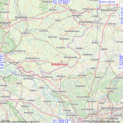
Bredevoort GPS coordinates[2]
51° 56' 30.012" North, 6° 37' 14.988" East
| Map corner | latitude | longitude |
|---|---|---|
| Upper-left | 52.37303°, | 5.91771° |
| Center: | 51.94167°, | 6.62083° |
| Lower-right: | 51.50612°, | 7.32396° |
| Map W x H: | 96.4×96.4 km | = 59.9×59.9mi |
| max Lat: | 53.48025° ⇑54.8% North |
| Bredevoort: | 51.94167° |
| min Lat: | ⇓45.2% South 50.76917° |
| min Long | Bredevoort | max Long |
| 3.38611° | 6.62083° | 7.16528° |
| W 91.8%⇐ | ⇒8.2% E |
Elevation
Elevation of Bredevoort is 28 m = 92 ft, and this is 13 m = 43 ft above average elevation for this country.
| Max E: |
203 m = 666 ft | 13.8% |
| Bredevoort | 28 m 92 ft | |
| Avg. | 15 m = 49 ft | |
Min E: |
-6 m = -20 ft | 86.2% |
See also: Netherlands elevation on elevation.city.
Geographical zone
Bredevoort is located in North temperate zone (between Tropic of Cancer and the Arctic Circle). Distance of this North polar circle is 1625.8 km =1010.2 mi to North.| Distance of | km | miles | from Bredevoort |
|---|---|---|---|
| North Pole | 4231.7 | 2629.5 | to North |
| Arctic Circle | 1625.8 | 1010.2 | to North |
| Tropic Cancer | 3169.5 | 1969.4 | to South |
| Equator | 5775.4 | 3588.7 | to South |


Nearby cities:
15 places around Bredevoort: (largest is in red/bold)
• Aalten
3.3 km =2.1 mi,  236°
236°
• Beltrum
14.4 km =8.9 mi,  344°
344°
• Eibergen
17.7 km =11 mi,  6°
6°
• Etten
19.7 km =12.2 mi,  261°
261°
• Gendringen
18.4 km =11.4 mi,  245°
245°
• Halle
14.2 km =8.8 mi,  291°
291°
• Lichtenvoorde
6.2 km =3.9 mi,  323°
323°
• Meddo
9.9 km =6.2 mi,  36°
36°
• Megchelen
19.4 km =12.1 mi,  233°
233°
• Silvolde
16.4 km =10.2 mi, 257°
• Terborg
18.4 km =11.4 mi, 262°
• Varsseveld
11.1 km =6.9 mi,  270°
270°
• Winterswijk
7.6 km =4.7 mi,  63°
63°
• Wisch
14.1 km =8.8 mi, 263°
• Zelhem
20 km =12.4 mi, 291°
Sources, notices
• [Note1] Compared only with cities in Netherlands existing in our database
• [Src1] Map data: © OpenStreetMap contributors (CC-BY-SA)
• [Src2] Other city data from geonames.org with taken over terms of usage.
• [Src3] Geographical zone / Annual Mean Temperature by Robert A. Rohde @ Wikipedia
