Keijenborg geodata
Keijenborg (Gelderland) is a populated place; located in Netherlands in Europe/Amsterdam (GMT+2) time zone. With population of 1,050 people, there are 1363 cities with bigger population in this country. Compared to other cities in Netherlands, 50.8% of cities are located further ↓South; 85.5% of cities are located further ←West and 69% of cities have lower elevation than Keijenborg. Note1


Keijenborg GPS coordinates[2]
52° 1' 45.012" North, 6° 17' 39.984" East
| Map corner | latitude | longitude |
|---|---|---|
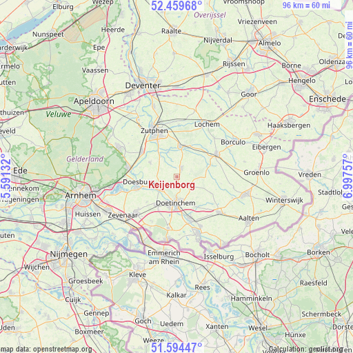
| Upper-left | 52.45968°, | 5.59132° |
| Center: | 52.02917°, | 6.29444° |
| Lower-right: | 51.59447°, | 6.99757° |
| Map W x H: | 96.2×96.2 km | = 59.8×59.8mi |
| max Lat: | 53.48025° ⇑49.2% North |
| Keijenborg: | 52.02917° |
| min Lat: | ⇓50.8% South 50.76917° |
| min Long | Keijenborg | max Long |
| 3.38611° | 6.29444° | 7.16528° |
| W 85.5%⇐ | ⇒14.5% E |
Elevation
Elevation of Keijenborg is 14 m = 46 ft, and this is 1 m = 3 ft below average elevation for this country.
| Max E: |
203 m = 666 ft | 31% |
| Avg. | 15 m = 49 ft | |
| Keijenborg | 14 m = 46 ft | |
Min E: |
-6 m = -20 ft | 69% |
See also: Netherlands elevation on elevation.city.
Geographical zone
Keijenborg is located in North temperate zone (between Tropic of Cancer and the Arctic Circle). Distance of this North polar circle is 1616.1 km =1004.2 mi to North.| Distance of | km | miles | from Keijenborg |
|---|---|---|---|
| North Pole | 4222 | 2623.4 | to North |
| Arctic Circle | 1616.1 | 1004.2 | to North |
| Tropic Cancer | 3179.2 | 1975.5 | to South |
| Equator | 5785.1 | 3594.7 | to South |


Nearby cities:
15 places around Keijenborg: (largest is in red/bold)
• Angerlo
11.5 km =7.1 mi,  251°
251°
• Baak
7 km =4.3 mi,  319°
319°
• Braamt
11.9 km =7.4 mi,  189°
189°
• Brummen
11.7 km =7.3 mi,  305°
305°
• Doesburg
10.8 km =6.7 mi,  260°
260°
• Doetinchem
7.1 km =4.4 mi,  183°
183°
• Drempt
8.5 km =5.3 mi, 253°
• Halle
10.2 km =6.3 mi,  115°
115°
• Hengelo
2.6 km =1.6 mi,  23°
23°
• Hummelo
5 km =3.1 mi,  236°
236°
• Kilder
11.1 km =6.9 mi,  202°
202°
• Leesten
11.8 km =7.3 mi,  338°
338°
• Steenderen
8.3 km =5.2 mi,  298°
298°
• Vorden
8.5 km =5.3 mi,  7°
7°
• Zelhem
4.5 km =2.8 mi, 124°
Sources, notices
• [Note1] Compared only with cities in Netherlands existing in our database
• [Src1] Map data: © OpenStreetMap contributors (CC-BY-SA)
• [Src2] Other city data from geonames.org with taken over terms of usage.
• [Src3] Geographical zone / Annual Mean Temperature by Robert A. Rohde @ Wikipedia
