Uithoorn geodata
Uithoorn (North Holland) is a populated place; located in Netherlands in Europe/Amsterdam (GMT+2) time zone. With population of 26,846 people, there are 119 cities with bigger population in this country. Compared to other cities in Netherlands, 63.7% of cities are located further ↓South; 78.6% of cities are located further →East and 99.9% of cities have higher elevation than Uithoorn. Note1


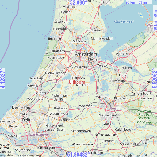
Uithoorn GPS coordinates[2]
52° 14' 15" North, 4° 49' 35.004" East
| Map corner | latitude | longitude |
|---|---|---|
| Upper-left | 52.666°, | 4.12327° |
| Center: | 52.2375°, | 4.82639° |
| Lower-right: | 51.80482°, | 5.52952° |
| Map W x H: | 95.8×95.8 km | = 59.5×59.5mi |
| max Lat: | 53.48025° ⇑36.3% North |
| Uithoorn: | 52.2375° |
| min Lat: | ⇓63.7% South 50.76917° |
| min Long | Uithoorn | max Long |
| 3.38611° | 4.82639° | 7.16528° |
| W 21.4%⇐ | ⇒78.6% E |
Elevation
Elevation of Uithoorn is -4 m = -13 ft, and this is 19 m = 62 ft below average elevation for this country.
| Max E: |
203 m = 666 ft | 99.9% |
| Avg. | 15 m = 49 ft | |
| Uithoorn | -4 m = -13 ft | |
Min E: |
-6 m = -20 ft | 0.1% |
See also: Netherlands elevation on elevation.city.
Geographical zone
Uithoorn is located in North temperate zone (between Tropic of Cancer and the Arctic Circle). Distance of this North polar circle is 1592.9 km =989.8 mi to North.| Distance of | km | miles | from Uithoorn |
|---|---|---|---|
| North Pole | 4198.8 | 2609 | to North |
| Arctic Circle | 1592.9 | 989.8 | to North |
| Tropic Cancer | 3202.3 | 1989.8 | to South |
| Equator | 5808.3 | 3609.1 | to South |


Nearby cities:
15 places around Uithoorn: (largest is in red/bold)
• Aalsmeer
5.1 km =3.2 mi,  297°
297°
• Aalsmeerderbrug
6.6 km =4.1 mi,  308°
308°
• Amstelveen
7.5 km =4.7 mi,  19°
19°
• Korteraar
9.6 km =6 mi,  222°
222°
• Kudelstaart
5.1 km =3.2 mi,  265°
265°
• Langeraar
9.3 km =5.8 mi,  237°
237°
• Mijdrecht
4.2 km =2.6 mi,  144°
144°
• Nieuwveen
6.6 km =4.1 mi,  226°
226°
• Oosteinde
5.1 km =3.2 mi,  335°
335°
• Ouderkerk aan de Amstel
8.4 km =5.2 mi,  40°
40°
• Papenveer
9 km =5.6 mi, 229°
• Vinkeveen
7.7 km =4.8 mi,  108°
108°
• Wilnis
6.6 km =4.1 mi,  133°
133°
• Woerdense Verlaat
9.5 km =5.9 mi,  164°
164°
• Zevenhoven
7 km =4.3 mi,  207°
207°
Sources, notices
• [Note1] Compared only with cities in Netherlands existing in our database
• [Src1] Map data: © OpenStreetMap contributors (CC-BY-SA)
• [Src2] Other city data from geonames.org with taken over terms of usage.
• [Src3] Geographical zone / Annual Mean Temperature by Robert A. Rohde @ Wikipedia
